El Puerto Magú geodata
El Puerto Magú (State of Mexico) is a populated place; located in Mexico in America/Mexico_City (GMT-6) time zone. With population of 3,433 people, there are 2652 cities with bigger population in this country. Compared to other cities in Mexico, 50.1% of cities are located further ↓South; 55.3% of cities are located further →East and 92.7% of cities have lower elevation than El Puerto Magú. Note1


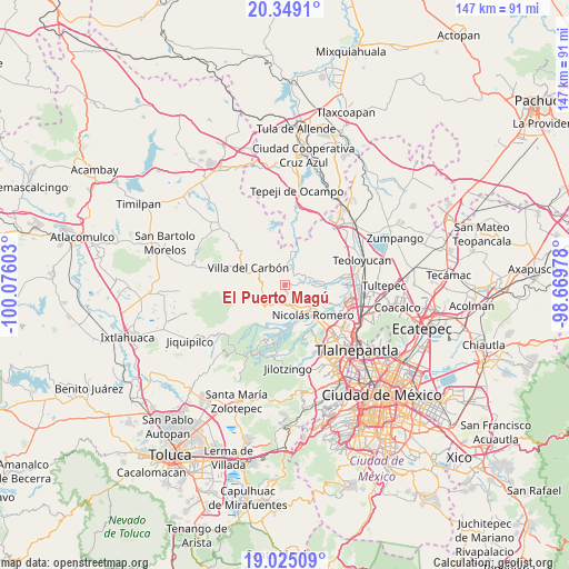
El Puerto Magú GPS coordinates[2]
19° 41' 18.456" North, 99° 22' 22.44" West
| Map corner | latitude | longitude |
|---|---|---|
| Upper-left | 20.3491°, | -100.07603° |
| Center: | 19.68846°, | -99.3729° |
| Lower-right: | 19.02509°, | -98.66978° |
| Map W x H: | 147.2×147.2 km | = 91.5×91.5mi |
| max Lat: | 32.7° ⇑49.9% North |
| El Puerto Magú: | 19.68846° |
| min Lat: | ⇓50.1% South 14.53588° |
| min Long | El Puerto Magú | max Long |
| -117.105° | -99.3729° | -86.73105° |
| W 44.7%⇐ | ⇒55.3% E |
Elevation
Elevation of El Puerto Magú is 2515 m = 8251 ft, and this is 1261.3 m = 4138 ft above average elevation for this country.
| Max E: |
3497 m = 11473 ft | 7.3% |
| El Puerto Magú | 2515 m 8251 ft | |
| Avg. | 1253.7 m = 4113 ft | |
Min E: |
-1 m = -3 ft | 92.7% |
See also: Mexico elevation on elevation.city.
Geographical zone
El Puerto Magú is located in North Torrid zone (between Equator and Tropic of Cancer). Distance of this Northern Tropic circle is 416.8 km =259 mi to North.| Distance of | km | miles | from El Puerto Magú |
|---|---|---|---|
| North Pole | 7817.9 | 4857.8 | to North |
| Arctic Circle | 5212 | 3238.6 | to North |
| Tropic Cancer | 416.8 | 259 | to North |
| Equator | 2189.2 | 1360.3 | to South |


Nearby cities:
15 places around El Puerto Magú: (largest is in red/bold)
• Caja de Agua
5.1 km =3.2 mi,  170°
170°
• Cañada de Cisneros
4 km =2.5 mi,  78°
78°
• Colonia Morelos
6.7 km =4.2 mi,  147°
147°
• Colonia San Miguel
3.7 km =2.3 mi,  205°
205°
• Colonia el Mirador
2.5 km =1.6 mi,  138°
138°
• El Esclavo
1.3 km =0.8 mi, 173°
• Joya del Tejocote
5.8 km =3.6 mi,  155°
155°
• Loma de Guadalupe (La Biznaga)
4.1 km =2.5 mi, 173°
• Progreso Industrial
6 km =3.7 mi, 163°
• San Francisco Magú
2.6 km =1.6 mi,  97°
97°
• San José el Vidrio
4.1 km =2.5 mi,  196°
196°
• San Juan de las Tablas
5.4 km =3.4 mi,  251°
251°
• San Martín Cachihuapan
6.5 km =4 mi,  289°
289°
• San Miguel Cañadas
4.7 km =2.9 mi,  37°
37°
• Santa Gertrudis
5 km =3.1 mi,  7°
7°
Sources, notices
• [Note1] Compared only with cities in Mexico existing in our database
• [Src1] Map data: © OpenStreetMap contributors (CC-BY-SA)
• [Src2] Other city data from geonames.org with taken over terms of usage.
• [Src3] Geographical zone / Annual Mean Temperature by Robert A. Rohde @ Wikipedia
