Colonia San Miguel geodata
Colonia San Miguel (State of Mexico) is a populated place; located in Mexico in America/Mexico_City (GMT-6) time zone. With population of 581 people, there are 14753 cities with bigger population in this country. Compared to other cities in Mexico, 50.7% of cities are located further ↑North; 55.5% of cities are located further →East and 95.9% of cities have lower elevation than Colonia San Miguel. Note1


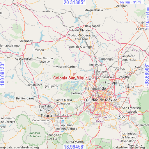
Colonia San Miguel GPS coordinates[2]
19° 39' 29.088" North, 99° 23' 17.52" West
| Map corner | latitude | longitude |
|---|---|---|
| Upper-left | 20.31885°, | -100.09133° |
| Center: | 19.65808°, | -99.3882° |
| Lower-right: | 18.99458°, | -98.68508° |
| Map W x H: | 147.2×147.2 km | = 91.5×91.5mi |
| max Lat: | 32.7° ⇑50.7% North |
| Colonia San Miguel: | 19.65808° |
| min Lat: | ⇓49.3% South 14.53588° |
| min Long | Colonia San Mig | max Long |
| -117.105° | -99.3882° | -86.73105° |
| W 44.5%⇐ | ⇒55.5% E |
Elevation
Elevation of Colonia San Miguel is 2620 m = 8596 ft, and this is 1366.3 m = 4483 ft above average elevation for this country.
| Max E: |
3497 m = 11473 ft | 4.1% |
| Colonia San Miguel | 2620 m 8596 ft | |
| Avg. | 1253.7 m = 4113 ft | |
Min E: |
-1 m = -3 ft | 95.9% |
See also: Mexico elevation on elevation.city.
Geographical zone
Colonia San Miguel is located in North Torrid zone (between Equator and Tropic of Cancer). Distance of this Northern Tropic circle is 420.1 km =261 mi to North.| Distance of | km | miles | from Colonia San Miguel |
|---|---|---|---|
| North Pole | 7821.3 | 4859.9 | to North |
| Arctic Circle | 5215.4 | 3240.7 | to North |
| Tropic Cancer | 420.1 | 261 | to North |
| Equator | 2185.8 | 1358.2 | to South |


Nearby cities:
15 places around Colonia San Miguel: (largest is in red/bold)
• Caja de Agua
2.9 km =1.8 mi,  124°
124°
• Colonia el Mirador
3.6 km =2.2 mi,  65°
65°
• El Esclavo
2.7 km =1.7 mi,  40°
40°
• El Puerto Magú
3.7 km =2.3 mi,  25°
25°
• Joya del Tejocote
4.4 km =2.7 mi,  114°
114°
• Loma de Chapultepec
5.4 km =3.4 mi,  206°
206°
• Loma de Guadalupe (La Biznaga)
2.1 km =1.3 mi, 107°
• Miranda
4.4 km =2.7 mi,  242°
242°
• Progreso Industrial
4.1 km =2.5 mi,  126°
126°
• Quinto Barrio (Ejido Cahuacán)
5.1 km =3.2 mi,  218°
218°
• San Francisco Magú
5.2 km =3.2 mi,  54°
54°
• San José el Vidrio
0.7 km =0.4 mi,  141°
141°
• San José los Barbechos (Los Barbechos)
3.7 km =2.3 mi, 244°
• San Juan de las Tablas
3.9 km =2.4 mi,  295°
295°
• Santa María Magdalena Cahuacán
3.5 km =2.2 mi,  229°
229°
Sources, notices
• [Note1] Compared only with cities in Mexico existing in our database
• [Src1] Map data: © OpenStreetMap contributors (CC-BY-SA)
• [Src2] Other city data from geonames.org with taken over terms of usage.
• [Src3] Geographical zone / Annual Mean Temperature by Robert A. Rohde @ Wikipedia
