Melchor Ocampo geodata
Melchor Ocampo (State of Mexico) is a seat of a second-order administrative division; located in Mexico in America/Mexico_City (GMT-6) time zone. With population of 38,599 people, there are 270 cities with bigger population in this country. Compared to other cities in Mexico, 50.5% of cities are located further ↓South; 51.7% of cities are located further →East and 85.1% of cities have lower elevation than Melchor Ocampo. Note1


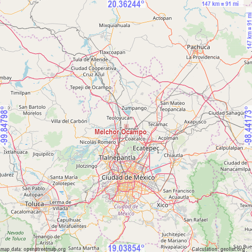
Melchor Ocampo GPS coordinates[2]
19° 42' 6.696" North, 99° 8' 41.46" West
| Map corner | latitude | longitude |
|---|---|---|
| Upper-left | 20.36244°, | -99.84798° |
| Center: | 19.70186°, | -99.14485° |
| Lower-right: | 19.03854°, | -98.44173° |
| Map W x H: | 147.2×147.2 km | = 91.5×91.5mi |
| max Lat: | 32.7° ⇑49.5% North |
| Melchor Ocampo: | 19.70186° |
| min Lat: | ⇓50.5% South 14.53588° |
| min Long | Melchor Ocampo | max Long |
| -117.105° | -99.14485° | -86.73105° |
| W 48.3%⇐ | ⇒51.7% E |
Elevation
Elevation of Melchor Ocampo is 2262 m = 7421 ft, and this is 1008.3 m = 3308 ft above average elevation for this country.
| Max E: |
3497 m = 11473 ft | 14.9% |
| Melchor Ocampo | 2262 m 7421 ft | |
| Avg. | 1253.7 m = 4113 ft | |
Min E: |
-1 m = -3 ft | 85.1% |
See also: Mexico elevation on elevation.city.
Geographical zone
Melchor Ocampo is located in North Torrid zone (between Equator and Tropic of Cancer). Distance of this Northern Tropic circle is 415.3 km =258.1 mi to North.| Distance of | km | miles | from Melchor Ocampo |
|---|---|---|---|
| North Pole | 7816.4 | 4856.9 | to North |
| Arctic Circle | 5210.5 | 3237.7 | to North |
| Tropic Cancer | 415.3 | 258.1 | to North |
| Equator | 2190.6 | 1361.2 | to South |


Nearby cities:
15 places around Melchor Ocampo: (largest is in red/bold)
• Colonia 2 de Septiembre
3 km =1.9 mi,  92°
92°
• Cuautitlán
5.1 km =3.2 mi,  226°
226°
• Ejido San Pablito (Paraje San Pablito)
4.5 km =2.8 mi,  142°
142°
• Fracción San Roque (El Prieto)
3.3 km =2.1 mi,  240°
240°
• La Trinidad
3.7 km =2.3 mi, 230°
• Lomas de Tenopalco
3.4 km =2.1 mi, 89°
• Los Álamos II
2.6 km =1.6 mi,  15°
15°
• Paraje Trigo Tenco
4 km =2.5 mi, 138°
• San Antonio Xahuento
4.1 km =2.5 mi,  106°
106°
• San Bartolo
3.6 km =2.2 mi,  334°
334°
• San Francisco Tenopalco
3.2 km =2 mi,  68°
68°
• San Mateo Ixtacalco
2.8 km =1.7 mi,  263°
263°
• Santa María Huecatitla
3.6 km =2.2 mi,  315°
315°
• Santiago Teyahualco
5.1 km =3.2 mi,  155°
155°
• Tultepec
2.6 km =1.6 mi, 136°
Sources, notices
• [Note1] Compared only with cities in Mexico existing in our database
• [Src1] Map data: © OpenStreetMap contributors (CC-BY-SA)
• [Src2] Other city data from geonames.org with taken over terms of usage.
• [Src3] Geographical zone / Annual Mean Temperature by Robert A. Rohde @ Wikipedia
