Santiago Teyahualco geodata
Santiago Teyahualco (State of Mexico) is a populated place; located in Mexico in America/Mexico_City (GMT-6) time zone. With population of 53,684 people, there are 210 cities with bigger population in this country. Compared to other cities in Mexico, 50.6% of cities are located further ↑North; 51.5% of cities are located further →East and 84.3% of cities have lower elevation than Santiago Teyahualco. Note1


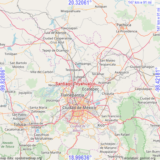
Santiago Teyahualco GPS coordinates[2]
19° 39' 35.46" North, 99° 7' 29.748" West
| Map corner | latitude | longitude |
|---|---|---|
| Upper-left | 20.32061°, | -99.82806° |
| Center: | 19.65985°, | -99.12493° |
| Lower-right: | 18.99636°, | -98.42181° |
| Map W x H: | 147.2×147.2 km | = 91.5×91.5mi |
| max Lat: | 32.7° ⇑50.6% North |
| Santiago Teyahualco: | 19.65985° |
| min Lat: | ⇓49.4% South 14.53588° |
| min Long | Santiago Teyahu | max Long |
| -117.105° | -99.12493° | -86.73105° |
| W 48.5%⇐ | ⇒51.5% E |
Elevation
Elevation of Santiago Teyahualco is 2249 m = 7379 ft, and this is 995.3 m = 3265 ft above average elevation for this country.
| Max E: |
3497 m = 11473 ft | 15.7% |
| Santiago Teyahualco | 2249 m 7379 ft | |
| Avg. | 1253.7 m = 4113 ft | |
Min E: |
-1 m = -3 ft | 84.3% |
See also: Santiago Teyahualco elevation on elevation.city.
Geographical zone
Santiago Teyahualco is located in North Torrid zone (between Equator and Tropic of Cancer). Distance of this Northern Tropic circle is 419.9 km =260.9 mi to North.| Distance of | km | miles | from Santiago Teyahualco |
|---|---|---|---|
| North Pole | 7821.1 | 4859.8 | to North |
| Arctic Circle | 5215.2 | 3240.6 | to North |
| Tropic Cancer | 419.9 | 260.9 | to North |
| Equator | 2186 | 1358.3 | to South |


Nearby cities:
15 places around Santiago Teyahualco: (largest is in red/bold)
• Ampliación San Mateo (Colonia Solidaridad)
5.4 km =3.4 mi,  205°
205°
• Coacalco
3.9 km =2.4 mi,  150°
150°
• Colonia 2 de Septiembre
4.6 km =2.9 mi,  10°
10°
• Colonia Lázaro Cárdenas (Los Hornos)
4.3 km =2.7 mi,  223°
223°
• Ejido San Pablito (Paraje San Pablito)
1.3 km =0.8 mi,  31°
31°
• Ejido de Teyahualco
2.6 km =1.6 mi,  243°
243°
• El Progreso (Villa Esmeralda)
5.2 km =3.2 mi,  54°
54°
• Fuentes del Valle
3.4 km =2.1 mi, 205°
• Lomas de Tenopalco
4.9 km =3 mi,  15°
15°
• Melchor Ocampo
5.1 km =3.2 mi,  335°
335°
• Paraje Trigo Tenco
1.8 km =1.1 mi, 19°
• San Antonio Xahuento
4 km =2.5 mi, 27°
• San Pablo de las Salinas
3.2 km =2 mi,  76°
76°
• Tultepec
2.8 km =1.7 mi,  353°
353°
• Tultitlán de Mariano Escobedo
4.7 km =2.9 mi,  251°
251°
Sources, notices
• [Note1] Compared only with cities in Mexico existing in our database
• [Src1] Map data: © OpenStreetMap contributors (CC-BY-SA)
• [Src2] Other city data from geonames.org with taken over terms of usage.
• [Src3] Geographical zone / Annual Mean Temperature by Robert A. Rohde @ Wikipedia
