Tayahua geodata
Tayahua (Zacatecas) is a populated place; located in Mexico in America/Mexico_City (GMT-6) time zone. With population of 2,193 people, there are 4008 cities with bigger population in this country. Compared to other cities in Mexico, 84.7% of cities are located further ↓South; 85.3% of cities are located further →East and 58.9% of cities have lower elevation than Tayahua. Note1


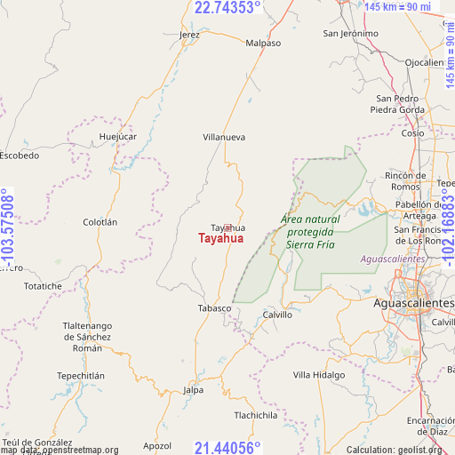
Tayahua GPS coordinates[2]
22° 5' 36.78" North, 102° 52' 19.02" West
| Map corner | latitude | longitude |
|---|---|---|
| Upper-left | 22.74353°, | -103.57508° |
| Center: | 22.09355°, | -102.87195° |
| Lower-right: | 21.44056°, | -102.16883° |
| Map W x H: | 144.9×144.9 km | = 90×90mi |
| max Lat: | 32.7° ⇑15.3% North |
| Tayahua: | 22.09355° |
| min Lat: | ⇓84.7% South 14.53588° |
| min Long | Tayahua | max Long |
| -117.105° | -102.87195° | -86.73105° |
| W 14.7%⇐ | ⇒85.3% E |
Elevation
Elevation of Tayahua is 1705 m = 5594 ft, and this is 451.3 m = 1481 ft above average elevation for this country.
| Max E: |
3497 m = 11473 ft | 41.1% |
| Tayahua | 1705 m 5594 ft | |
| Avg. | 1253.7 m = 4113 ft | |
Min E: |
-1 m = -3 ft | 58.9% |
See also: Mexico elevation on elevation.city.
Geographical zone
Tayahua is located in North Torrid zone (between Equator and Tropic of Cancer). Distance of this Northern Tropic circle is 149.3 km =92.8 mi to North.| Distance of | km | miles | from Tayahua |
|---|---|---|---|
| North Pole | 7550.5 | 4691.7 | to North |
| Arctic Circle | 4944.6 | 3072.4 | to North |
| Tropic Cancer | 149.3 | 92.8 | to North |
| Equator | 2456.6 | 1526.5 | to South |


Nearby cities:
15 places around Tayahua: (largest is in red/bold)
• Calvillo
31.8 km =19.8 mi,  150°
150°
• El Plateado de Joaquín Amaro
28.7 km =17.8 mi,  232°
232°
• El Salto
28.2 km =17.5 mi,  343°
343°
• Huiscolco
23.4 km =14.5 mi,  198°
198°
• La Encarnación
17.8 km =11.1 mi, 342°
• La Labor
23.3 km =14.5 mi,  128°
128°
• La Panadera
31.2 km =19.4 mi,  144°
144°
• Ojocaliente
31.6 km =19.6 mi, 140°
• San Luis de Custique
12.9 km =8 mi,  178°
178°
• San Tadeo
26.2 km =16.3 mi, 137°
• Saúz de los Márquez
25.5 km =15.8 mi,  275°
275°
• Solidaridad [Fraccionamiento]
28.6 km =17.8 mi, 143°
• Tabasco
26 km =16.2 mi,  188°
188°
• Valle Huejúcar (Fraccionamiento Popular) [Fraccionamiento]
31.8 km =19.8 mi,  156°
156°
• Villanueva
29.1 km =18.1 mi,  357°
357°
Sources, notices
• [Note1] Compared only with cities in Mexico existing in our database
• [Src1] Map data: © OpenStreetMap contributors (CC-BY-SA)
• [Src2] Other city data from geonames.org with taken over terms of usage.
• [Src3] Geographical zone / Annual Mean Temperature by Robert A. Rohde @ Wikipedia
