Ojocaliente geodata
Ojocaliente (Aguascalientes) is a populated place; located in Mexico in America/Mexico_City (GMT-6) time zone. With population of 6,914 people, there are 1347 cities with bigger population in this country. Compared to other cities in Mexico, 83.4% of cities are located further ↓South; 84.7% of cities are located further →East and 57.6% of cities have lower elevation than Ojocaliente. Note1


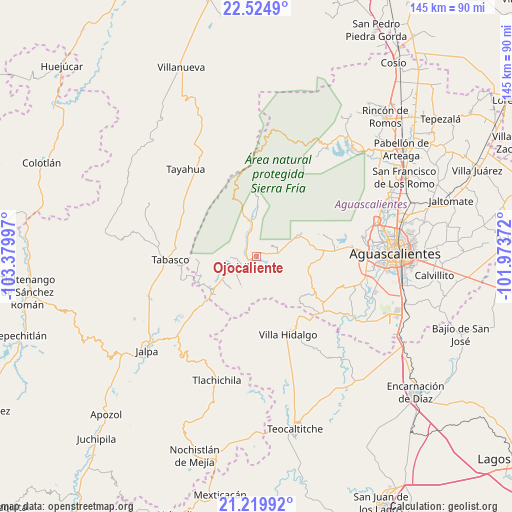
Ojocaliente GPS coordinates[2]
21° 52' 26.04" North, 102° 40' 36.624" West
| Map corner | latitude | longitude |
|---|---|---|
| Upper-left | 22.5249°, | -103.37997° |
| Center: | 21.8739°, | -102.67684° |
| Lower-right: | 21.21992°, | -101.97372° |
| Map W x H: | 145.1×145.1 km | = 90.2×90.2mi |
| max Lat: | 32.7° ⇑16.6% North |
| Ojocaliente: | 21.8739° |
| min Lat: | ⇓83.4% South 14.53588° |
| min Long | Ojocaliente | max Long |
| -117.105° | -102.67684° | -86.73105° |
| W 15.3%⇐ | ⇒84.7% E |
Elevation
Elevation of Ojocaliente is 1681 m = 5515 ft, and this is 427.3 m = 1402 ft above average elevation for this country.
| Max E: |
3497 m = 11473 ft | 42.4% |
| Ojocaliente | 1681 m 5515 ft | |
| Avg. | 1253.7 m = 4113 ft | |
Min E: |
-1 m = -3 ft | 57.6% |
See also: Mexico elevation on elevation.city.
Geographical zone
Ojocaliente is located in North Torrid zone (between Equator and Tropic of Cancer). Distance of this Northern Tropic circle is 173.8 km =108 mi to North.| Distance of | km | miles | from Ojocaliente |
|---|---|---|---|
| North Pole | 7574.9 | 4706.8 | to North |
| Arctic Circle | 4969 | 3087.6 | to North |
| Tropic Cancer | 173.8 | 108 | to North |
| Equator | 2432.1 | 1511.2 | to South |


Nearby cities:
15 places around Ojocaliente: (largest is in red/bold)
• Calvillo
5.3 km =3.3 mi,  234°
234°
• Crucero Las Pilas
10.1 km =6.3 mi,  238°
238°
• El Cuervero (Cuerveros)
1.7 km =1.1 mi,  206°
206°
• El Salitre
11.4 km =7.1 mi, 238°
• Jaltiche de Arriba
15.9 km =9.9 mi, 226°
• La Labor
10 km =6.2 mi,  348°
348°
• La Panadera
2.5 km =1.6 mi, 243°
• La Rinconada
15.6 km =9.7 mi, 233°
• Malpaso
2.1 km =1.3 mi,  142°
142°
• Mesa Grande
8.9 km =5.5 mi, 211°
• Ojo de Agua
14.1 km =8.8 mi, 231°
• San Tadeo
5.6 km =3.5 mi,  334°
334°
• Solidaridad [Fraccionamiento]
3.4 km =2.1 mi,  296°
296°
• Tapias Viejas
14.7 km =9.1 mi,  101°
101°
• Valle Huejúcar (Fraccionamiento Popular) [Fraccionamiento]
8.9 km =5.5 mi, 237°
Sources, notices
• [Note1] Compared only with cities in Mexico existing in our database
• [Src1] Map data: © OpenStreetMap contributors (CC-BY-SA)
• [Src2] Other city data from geonames.org with taken over terms of usage.
• [Src3] Geographical zone / Annual Mean Temperature by Robert A. Rohde @ Wikipedia
