La Encantada geodata
La Encantada (Zacatecas) is a populated place; located in Mexico in America/Mexico_City (GMT-6) time zone. With population of 680 people, there are 12778 cities with bigger population in this country. Compared to other cities in Mexico, 88.9% of cities are located further ↓South; 85.3% of cities are located further →East and 75.9% of cities have lower elevation than La Encantada. Note1


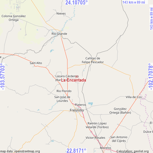
La Encantada GPS coordinates[2]
23° 27' 49.14" North, 102° 52' 26.04" West
| Map corner | latitude | longitude |
|---|---|---|
| Upper-left | 24.10705°, | -103.57703° |
| Center: | 23.46365°, | -102.8739° |
| Lower-right: | 22.8171°, | -102.17078° |
| Map W x H: | 143.4×143.4 km | = 89.1×89.1mi |
| max Lat: | 32.7° ⇑11.1% North |
| La Encantada: | 23.46365° |
| min Lat: | ⇓88.9% South 14.53588° |
| min Long | La Encantada | max Long |
| -117.105° | -102.8739° | -86.73105° |
| W 14.7%⇐ | ⇒85.3% E |
Elevation
Elevation of La Encantada is 2047 m = 6716 ft, and this is 793.3 m = 2603 ft above average elevation for this country.
| Max E: |
3497 m = 11473 ft | 24.1% |
| La Encantada | 2047 m 6716 ft | |
| Avg. | 1253.7 m = 4113 ft | |
Min E: |
-1 m = -3 ft | 75.9% |
See also: Mexico elevation on elevation.city.
Geographical zone
La Encantada is located in North temperate zone (between Tropic of Cancer and the Arctic Circle). Distance of this Northern Tropic circle is 3 km =1.9 mi to South.| Distance of | km | miles | from La Encantada |
|---|---|---|---|
| North Pole | 7398.1 | 4597 | to North |
| Arctic Circle | 4792.3 | 2977.8 | to North |
| Tropic Cancer | 3 | 1.9 | to South |
| Equator | 2608.9 | 1621.1 | to South |


Nearby cities:
15 places around La Encantada: (largest is in red/bold)
• Altamira
14.7 km =9.1 mi,  231°
231°
• Boquilla de Abajo
10.2 km =6.3 mi,  5°
5°
• Boquilla de Arriba
11.5 km =7.1 mi,  350°
350°
• Cañitas de Felipe Pescador
21.6 km =13.4 mi,  43°
43°
• El Baluarte
17.8 km =11.1 mi,  247°
247°
• Estación Gutiérrez
9 km =5.6 mi,  102°
102°
• José María Morelos
21.2 km =13.2 mi,  222°
222°
• La Quemada
8.2 km =5.1 mi,  50°
50°
• La Salada
2 km =1.2 mi,  200°
200°
• Lázaro Cárdenas (Rancho Grande)
9.2 km =5.7 mi,  260°
260°
• Milpillas de la Sierra
13.3 km =8.3 mi,  68°
68°
• Rio de Medina
15.3 km =9.5 mi,  286°
286°
• Río Florido
17.8 km =11.1 mi, 221°
• San Ignacio
19.6 km =12.2 mi, 219°
• San Pablo de Rancho Grande
10.6 km =6.6 mi,  337°
337°
Sources, notices
• [Note1] Compared only with cities in Mexico existing in our database
• [Src1] Map data: © OpenStreetMap contributors (CC-BY-SA)
• [Src2] Other city data from geonames.org with taken over terms of usage.
• [Src3] Geographical zone / Annual Mean Temperature by Robert A. Rohde @ Wikipedia
