Lázaro Cárdenas (Rancho Grande) geodata
Lázaro Cárdenas (Rancho Grande) (Zacatecas) is a populated place; located in Mexico in America/Mexico_City (GMT-6) time zone. With population of 3,857 people, there are 2375 cities with bigger population in this country. Compared to other cities in Mexico, 88.9% of cities are located further ↓South; 85.6% of cities are located further →East and 74.5% of cities have lower elevation than Lázaro Cárdenas (Rancho Grande). Note1
Current local time in Lázaro Cárdenas (Rancho Grande):
06:45 AM, WednesdayDifference from your time zone: hours


Lázaro Cárdenas (Rancho Grande) GPS coordinates[2]
23° 27' 2.016" North, 102° 57' 45" West
| Map corner | latitude | longitude |
|---|---|---|
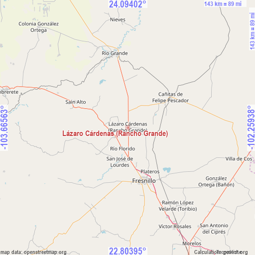
| Upper-left | 24.09402°, | -103.66563° |
| Center: | 23.45056°, | -102.9625° |
| Lower-right: | 22.80395°, | -102.25938° |
| Map W x H: | 143.4×143.4 km | = 89.1×89.1mi |
| max Lat: | 32.7° ⇑11.1% North |
| Lázaro Cárdenas (Rancho Grande): | 23.45056° |
| min Lat: | ⇓88.9% South 14.53588° |
| min Long | Lázaro Cárden | max Long |
| -117.105° | -102.9625° | -86.73105° |
| W 14.4%⇐ | ⇒85.6% E |
Elevation
Elevation of Lázaro Cárdenas (Rancho Grande) is 2022 m = 6634 ft, and this is 768.3 m = 2521 ft above average elevation for this country.
| Max E: |
3497 m = 11473 ft | 25.5% |
| Lázaro Cárdenas (Rancho Grande) | 2022 m 6634 ft | |
| Avg. | 1253.7 m = 4113 ft | |
Min E: |
-1 m = -3 ft | 74.5% |
See also: Mexico elevation on elevation.city.
Geographical zone
Lázaro Cárdenas (Rancho Grande) is located in North temperate zone (between Tropic of Cancer and the Arctic Circle). Distance of this Northern Tropic circle is 1.5 km =0.9 mi to South.| Distance of | km | miles | from Lázaro Cárdenas (Rancho Grande) |
|---|---|---|---|
| North Pole | 7399.6 | 4597.9 | to North |
| Arctic Circle | 4793.7 | 2978.7 | to North |
| Tropic Cancer | 1.5 | 0.9 | to South |
| Equator | 2607.5 | 1620.2 | to South |


Nearby cities:
15 places around Lázaro Cárdenas (Rancho Grande): (largest is in red/bold)
• Altamira
8 km =5 mi,  197°
197°
• Boquilla de Abajo
15.3 km =9.5 mi,  40°
40°
• Boquilla de Arriba
14.6 km =9.1 mi,  28°
28°
• El Baluarte
9.1 km =5.7 mi,  234°
234°
• Estación Gutiérrez
17.8 km =11.1 mi,  91°
91°
• José María Morelos
15.2 km =9.4 mi, 200°
• La Encantada
9.2 km =5.7 mi,  80°
80°
• La Quemada
16.7 km =10.4 mi,  66°
66°
• La Salada
8.4 km =5.2 mi, 93°
• Rio de Medina
8.1 km =5 mi,  315°
315°
• Río Florido
12.1 km =7.5 mi,  193°
193°
• San Gabriel
17 km =10.6 mi, 189°
• San Ignacio
14.1 km =8.8 mi, 193°
• San Pablo de Rancho Grande
12.3 km =7.6 mi,  23°
23°
• Seis de Enero
14.6 km =9.1 mi, 231°
Sources, notices
• [Note1] Compared only with cities in Mexico existing in our database
• [Src1] Map data: © OpenStreetMap contributors (CC-BY-SA)
• [Src2] Other city data from geonames.org with taken over terms of usage.
• [Src3] Geographical zone / Annual Mean Temperature by Robert A. Rohde @ Wikipedia
