El Baluarte geodata
El Baluarte (Zacatecas) is a populated place; located in Mexico in America/Mexico_City (GMT-6) time zone. With population of 980 people, there are 8875 cities with bigger population in this country. Compared to other cities in Mexico, 88.8% of cities are located further ↓South; 85.9% of cities are located further →East and 77.9% of cities have lower elevation than El Baluarte. Note1


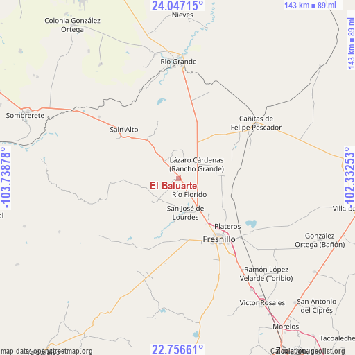
El Baluarte GPS coordinates[2]
23° 24' 12.42" North, 103° 2' 8.34" West
| Map corner | latitude | longitude |
|---|---|---|
| Upper-left | 24.04715°, | -103.73878° |
| Center: | 23.40345°, | -103.03565° |
| Lower-right: | 22.75661°, | -102.33253° |
| Map W x H: | 143.5×143.5 km | = 89.2×89.2mi |
| max Lat: | 32.7° ⇑11.2% North |
| El Baluarte: | 23.40345° |
| min Lat: | ⇓88.8% South 14.53588° |
| min Long | El Baluarte | max Long |
| -117.105° | -103.03565° | -86.73105° |
| W 14.1%⇐ | ⇒85.9% E |
Elevation
Elevation of El Baluarte is 2087 m = 6847 ft, and this is 833.3 m = 2734 ft above average elevation for this country.
| Max E: |
3497 m = 11473 ft | 22.1% |
| El Baluarte | 2087 m 6847 ft | |
| Avg. | 1253.7 m = 4113 ft | |
Min E: |
-1 m = -3 ft | 77.9% |
See also: Mexico elevation on elevation.city.
Geographical zone
El Baluarte is located in North Torrid zone (between Equator and Tropic of Cancer). Distance of this Northern Tropic circle is 3.7 km =2.3 mi to North.| Distance of | km | miles | from El Baluarte |
|---|---|---|---|
| North Pole | 7404.8 | 4601.1 | to North |
| Arctic Circle | 4799 | 2982 | to North |
| Tropic Cancer | 3.7 | 2.3 | to North |
| Equator | 2602.2 | 1616.9 | to South |


Nearby cities:
15 places around El Baluarte: (largest is in red/bold)
• Altamira
5.5 km =3.4 mi,  115°
115°
• Colonia Montemariana (Colonia Mariana)
11.6 km =7.2 mi,  222°
222°
• Colonia Plenitud
19.4 km =12.1 mi,  191°
191°
• El Ahijadero
14.3 km =8.9 mi,  229°
229°
• José María Morelos
9.2 km =5.7 mi,  166°
166°
• La Encantada
17.8 km =11.1 mi,  67°
67°
• La Salada
16.5 km =10.3 mi, 73°
• Lázaro Cárdenas (Rancho Grande)
9.1 km =5.7 mi,  54°
54°
• Ramón López Velarde
19.4 km =12.1 mi,  139°
139°
• Rio de Medina
11.2 km =7 mi,  9°
9°
• Río Florido
8 km =5 mi, 144°
• San Gabriel
12.3 km =7.6 mi,  158°
158°
• San Ignacio
9.4 km =5.8 mi,  154°
154°
• San Jose de Lourdes
14.4 km =8.9 mi, 169°
• Seis de Enero
5.6 km =3.5 mi, 225°
Sources, notices
• [Note1] Compared only with cities in Mexico existing in our database
• [Src1] Map data: © OpenStreetMap contributors (CC-BY-SA)
• [Src2] Other city data from geonames.org with taken over terms of usage.
• [Src3] Geographical zone / Annual Mean Temperature by Robert A. Rohde @ Wikipedia
