Alberto Carrera Torres geodata
Alberto Carrera Torres (San Luis Potosí) is a populated place; located in Mexico in America/Mexico_City (GMT-6) time zone. With population of 1,109 people, there are 7837 cities with bigger population in this country. Compared to other cities in Mexico, 82.8% of cities are located further ↓South; 73.6% of cities are located further →East and 65.5% of cities have lower elevation than Alberto Carrera Torres. Note1
Current local time in Alberto Carrera Torres:
06:46 AM, WednesdayDifference from your time zone: hours


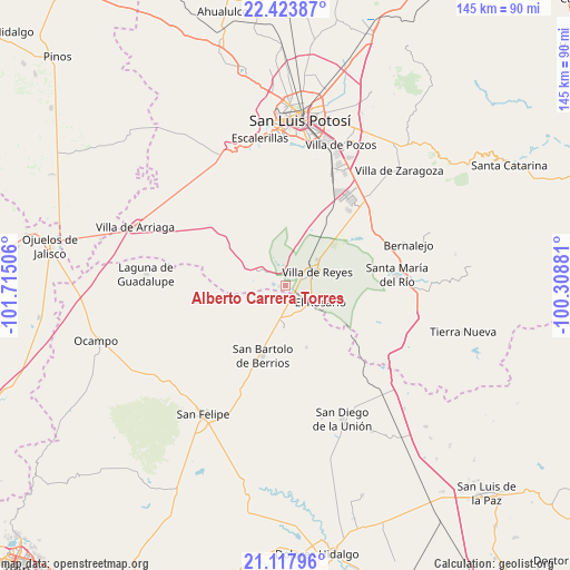
Alberto Carrera Torres GPS coordinates[2]
21° 46' 20.64" North, 101° 0' 42.948" West
| Map corner | latitude | longitude |
|---|---|---|
| Upper-left | 22.42387°, | -101.71506° |
| Center: | 21.7724°, | -101.01193° |
| Lower-right: | 21.11796°, | -100.30881° |
| Map W x H: | 145.2×145.2 km | = 90.2×90.2mi |
| max Lat: | 32.7° ⇑17.2% North |
| Alberto Carrera Torres: | 21.7724° |
| min Lat: | ⇓82.8% South 14.53588° |
| min Long | Alberto Carrera | max Long |
| -117.105° | -101.01193° | -86.73105° |
| W 26.4%⇐ | ⇒73.6% E |
Elevation
Elevation of Alberto Carrera Torres is 1841 m = 6040 ft, and this is 587.3 m = 1927 ft above average elevation for this country.
| Max E: |
3497 m = 11473 ft | 34.5% |
| Alberto Carrera Torres | 1841 m 6040 ft | |
| Avg. | 1253.7 m = 4113 ft | |
Min E: |
-1 m = -3 ft | 65.5% |
See also: Mexico elevation on elevation.city.
Geographical zone
Alberto Carrera Torres is located in North Torrid zone (between Equator and Tropic of Cancer). Distance of this Northern Tropic circle is 185.1 km =115 mi to North.| Distance of | km | miles | from Alberto Carrera Torres |
|---|---|---|---|
| North Pole | 7586.2 | 4713.8 | to North |
| Arctic Circle | 4980.3 | 3094.6 | to North |
| Tropic Cancer | 185.1 | 115 | to North |
| Equator | 2420.9 | 1504.3 | to South |


Nearby cities:
15 places around Alberto Carrera Torres: (largest is in red/bold)
• Bledos
13.2 km =8.2 mi,  305°
305°
• Carranco
10.3 km =6.4 mi,  301°
301°
• Ejido Gogorrón (Ex-Hacienda de Gogorrón)
12.8 km =8 mi,  54°
54°
• Ejido el Saucillo
7.4 km =4.6 mi,  13°
13°
• El Centenario
6.8 km =4.2 mi,  88°
88°
• El Rosario
9.8 km =6.1 mi,  115°
115°
• El Zapote
5.6 km =3.5 mi,  223°
223°
• Estancia de San Francisco
13 km =8.1 mi,  204°
204°
• Guadalupe
7.2 km =4.5 mi,  149°
149°
• Guadiana
1.8 km =1.1 mi,  33°
33°
• La Ventilla
1.9 km =1.2 mi,  274°
274°
• Machado
13.7 km =8.5 mi, 34°
• Rodrigo
14.6 km =9.1 mi,  24°
24°
• San Miguel
6.8 km =4.2 mi,  103°
103°
• Villa de Reyes
8.7 km =5.4 mi,  66°
66°
Sources, notices
• [Note1] Compared only with cities in Mexico existing in our database
• [Src1] Map data: © OpenStreetMap contributors (CC-BY-SA)
• [Src2] Other city data from geonames.org with taken over terms of usage.
• [Src3] Geographical zone / Annual Mean Temperature by Robert A. Rohde @ Wikipedia
