Guadalupe geodata
Guadalupe (Guanajuato) is a populated place; located in Mexico in America/Mexico_City (GMT-6) time zone. With population of 1,485 people, there are 5810 cities with bigger population in this country. Compared to other cities in Mexico, 82.5% of cities are located further ↓South; 73.3% of cities are located further →East and 65.3% of cities have lower elevation than Guadalupe. Note1


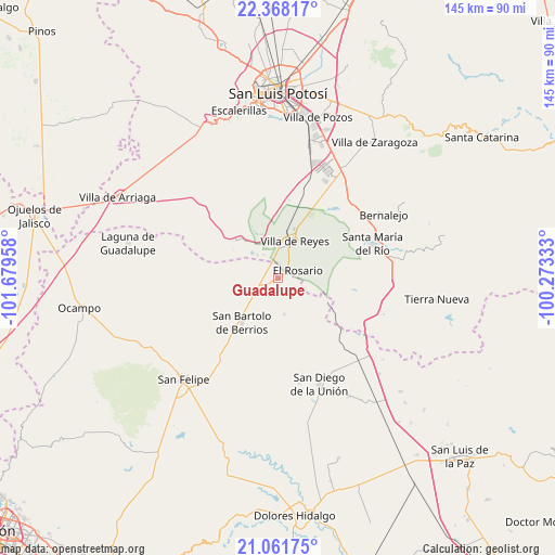
Guadalupe GPS coordinates[2]
21° 42' 59.184" North, 100° 58' 35.22" West
| Map corner | latitude | longitude |
|---|---|---|
| Upper-left | 22.36817°, | -101.67958° |
| Center: | 21.71644°, | -100.97645° |
| Lower-right: | 21.06175°, | -100.27333° |
| Map W x H: | 145.3×145.3 km | = 90.3×90.3mi |
| max Lat: | 32.7° ⇑17.5% North |
| Guadalupe: | 21.71644° |
| min Lat: | ⇓82.5% South 14.53588° |
| min Long | Guadalupe | max Long |
| -117.105° | -100.97645° | -86.73105° |
| W 26.7%⇐ | ⇒73.3% E |
Elevation
Elevation of Guadalupe is 1835 m = 6020 ft, and this is 581.3 m = 1907 ft above average elevation for this country.
| Max E: |
3497 m = 11473 ft | 34.7% |
| Guadalupe | 1835 m 6020 ft | |
| Avg. | 1253.7 m = 4113 ft | |
Min E: |
-1 m = -3 ft | 65.3% |
See also: Mexico elevation on elevation.city.
Geographical zone
Guadalupe is located in North Torrid zone (between Equator and Tropic of Cancer). Distance of this Northern Tropic circle is 191.3 km =118.9 mi to North.| Distance of | km | miles | from Guadalupe |
|---|---|---|---|
| North Pole | 7592.4 | 4717.7 | to North |
| Arctic Circle | 4986.5 | 3098.5 | to North |
| Tropic Cancer | 191.3 | 118.9 | to North |
| Equator | 2414.6 | 1500.4 | to South |


Nearby cities:
15 places around Guadalupe: (largest is in red/bold)
• Alberto Carrera Torres
7.2 km =4.5 mi,  329°
329°
• Ejido el Saucillo
13.5 km =8.4 mi,  351°
351°
• El Carretón
9.6 km =6 mi,  182°
182°
• El Centenario
7.2 km =4.5 mi,  26°
26°
• El Rosario
5.5 km =3.4 mi,  69°
69°
• El Tejocote (El Domingo)
7.8 km =4.8 mi,  125°
125°
• El Zapote
7.8 km =4.8 mi,  285°
285°
• Emiliano Zapata
9.5 km =5.9 mi,  169°
169°
• Estancia de San Francisco
10.7 km =6.6 mi,  238°
238°
• Fábrica de Melchor
9.2 km =5.7 mi,  122°
122°
• Guadiana
8.2 km =5.1 mi,  341°
341°
• La Ventilla
8.5 km =5.3 mi,  318°
318°
• San Francisco
12.5 km =7.8 mi,  222°
222°
• San Miguel
5.4 km =3.4 mi, 32°
• Villa de Reyes
10.6 km =6.6 mi,  24°
24°
Sources, notices
• [Note1] Compared only with cities in Mexico existing in our database
• [Src1] Map data: © OpenStreetMap contributors (CC-BY-SA)
• [Src2] Other city data from geonames.org with taken over terms of usage.
• [Src3] Geographical zone / Annual Mean Temperature by Robert A. Rohde @ Wikipedia
