Xoconoxtle geodata
Xoconoxtle (San Luis Potosí) is a populated place; located in Mexico in America/Mexico_City (GMT-6) time zone. With population of 788 people, there are 11082 cities with bigger population in this country. Compared to other cities in Mexico, 84.7% of cities are located further ↓South; 71.1% of cities are located further →East and 77% of cities have lower elevation than Xoconoxtle. Note1


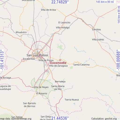
Xoconoxtle GPS coordinates[2]
22° 5' 53.988" North, 100° 42' 36" West
| Map corner | latitude | longitude |
|---|---|---|
| Upper-left | 22.74829°, | -101.41313° |
| Center: | 22.09833°, | -100.71° |
| Lower-right: | 21.44536°, | -100.00688° |
| Map W x H: | 144.9×144.9 km | = 90×90mi |
| max Lat: | 32.7° ⇑15.3% North |
| Xoconoxtle: | 22.09833° |
| min Lat: | ⇓84.7% South 14.53588° |
| min Long | Xoconoxtle | max Long |
| -117.105° | -100.71° | -86.73105° |
| W 28.9%⇐ | ⇒71.1% E |
Elevation
Elevation of Xoconoxtle is 2069 m = 6788 ft, and this is 815.3 m = 2675 ft above average elevation for this country.
| Max E: |
3497 m = 11473 ft | 23% |
| Xoconoxtle | 2069 m 6788 ft | |
| Avg. | 1253.7 m = 4113 ft | |
Min E: |
-1 m = -3 ft | 77% |
See also: Mexico elevation on elevation.city.
Geographical zone
Xoconoxtle is located in North Torrid zone (between Equator and Tropic of Cancer). Distance of this Northern Tropic circle is 148.8 km =92.5 mi to North.| Distance of | km | miles | from Xoconoxtle |
|---|---|---|---|
| North Pole | 7550 | 4691.4 | to North |
| Arctic Circle | 4944.1 | 3072.1 | to North |
| Tropic Cancer | 148.8 | 92.5 | to North |
| Equator | 2457.1 | 1526.8 | to South |


Nearby cities:
15 places around Xoconoxtle: (largest is in red/bold)
• Armadillo de los Infante
17.2 km =10.7 mi,  18°
18°
• Bosques la Florida
16 km =9.9 mi,  290°
290°
• Cerro Gordo
17 km =10.6 mi,  215°
215°
• Cerro de San Pedro
16.2 km =10.1 mi,  325°
325°
• Ciudad Satélite
9 km =5.6 mi,  278°
278°
• El Jaralito
13.2 km =8.2 mi,  239°
239°
• La Esperanza
11.5 km =7.1 mi,  209°
209°
• La Parada del Zarcido
2.3 km =1.4 mi,  153°
153°
• Laguna de Santa Rita
14.2 km =8.8 mi, 277°
• Noria San José
17 km =10.6 mi,  255°
255°
• Panalillo
12.1 km =7.5 mi,  297°
297°
• Portezuelo
14.3 km =8.9 mi, 303°
• San José de Gómez
2.7 km =1.7 mi,  1°
1°
• Tanque el Jagüey
15.1 km =9.4 mi, 277°
• Villa Zaragoza
7.1 km =4.4 mi,  197°
197°
Sources, notices
• [Note1] Compared only with cities in Mexico existing in our database
• [Src1] Map data: © OpenStreetMap contributors (CC-BY-SA)
• [Src2] Other city data from geonames.org with taken over terms of usage.
• [Src3] Geographical zone / Annual Mean Temperature by Robert A. Rohde @ Wikipedia
