La Esperanza geodata
La Esperanza (San Luis Potosí) is a populated place; located in Mexico in America/Mexico_City (GMT-6) time zone. With population of 2,054 people, there are 4243 cities with bigger population in this country. Compared to other cities in Mexico, 84.3% of cities are located further ↓South; 71.6% of cities are located further →East and 69.9% of cities have lower elevation than La Esperanza. Note1


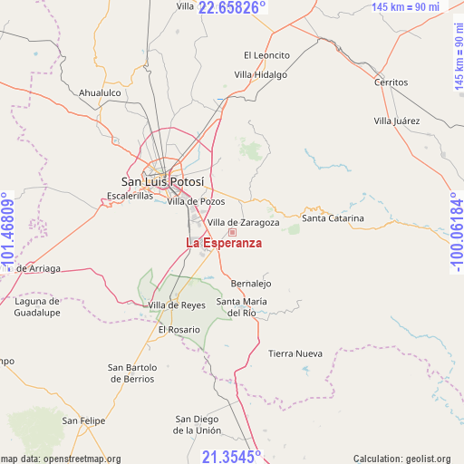
La Esperanza GPS coordinates[2]
22° 0' 28.368" North, 100° 45' 53.856" West
| Map corner | latitude | longitude |
|---|---|---|
| Upper-left | 22.65826°, | -101.46809° |
| Center: | 22.00788°, | -100.76496° |
| Lower-right: | 21.3545°, | -100.06184° |
| Map W x H: | 145×145 km | = 90.1×90.1mi |
| max Lat: | 32.7° ⇑15.7% North |
| La Esperanza: | 22.00788° |
| min Lat: | ⇓84.3% South 14.53588° |
| min Long | La Esperanza | max Long |
| -117.105° | -100.76496° | -86.73105° |
| W 28.4%⇐ | ⇒71.6% E |
Elevation
Elevation of La Esperanza is 1921 m = 6302 ft, and this is 667.3 m = 2189 ft above average elevation for this country.
| Max E: |
3497 m = 11473 ft | 30.1% |
| La Esperanza | 1921 m 6302 ft | |
| Avg. | 1253.7 m = 4113 ft | |
Min E: |
-1 m = -3 ft | 69.9% |
See also: Mexico elevation on elevation.city.
Geographical zone
La Esperanza is located in North Torrid zone (between Equator and Tropic of Cancer). Distance of this Northern Tropic circle is 158.9 km =98.7 mi to North.| Distance of | km | miles | from La Esperanza |
|---|---|---|---|
| North Pole | 7560 | 4697.6 | to North |
| Arctic Circle | 4954.1 | 3078.3 | to North |
| Tropic Cancer | 158.9 | 98.7 | to North |
| Equator | 2447 | 1520.5 | to South |


Nearby cities:
15 places around La Esperanza: (largest is in red/bold)
• Cerro Gordo
5.7 km =3.5 mi,  229°
229°
• Ciudad Satélite
11.9 km =7.4 mi,  344°
344°
• El Jaralito
6.7 km =4.2 mi,  300°
300°
• El Terrero Sur
15.2 km =9.4 mi,  283°
283°
• Enramadas
14 km =8.7 mi,  187°
187°
• La Parada del Zarcido
10.4 km =6.5 mi,  39°
39°
• La Pila
11 km =6.8 mi,  285°
285°
• Laguna de San Vicente
11.9 km =7.4 mi, 234°
• Laguna de Santa Rita
14.6 km =9.1 mi,  324°
324°
• Noria San José
12.3 km =7.6 mi, 298°
• San José de Gómez
14 km =8.7 mi,  24°
24°
• Tanque el Jagüey
15.2 km =9.4 mi, 321°
• Texas
7.4 km =4.6 mi,  163°
163°
• Villa Zaragoza
4.8 km =3 mi,  47°
47°
• Xoconoxtle
11.5 km =7.1 mi,  29°
29°
Sources, notices
• [Note1] Compared only with cities in Mexico existing in our database
• [Src1] Map data: © OpenStreetMap contributors (CC-BY-SA)
• [Src2] Other city data from geonames.org with taken over terms of usage.
• [Src3] Geographical zone / Annual Mean Temperature by Robert A. Rohde @ Wikipedia
