Cerro Gordo geodata
Cerro Gordo (San Luis Potosí) is a populated place; located in Mexico in America/Mexico_City (GMT-6) time zone. With population of 2,123 people, there are 4123 cities with bigger population in this country. Compared to other cities in Mexico, 84% of cities are located further ↓South; 71.9% of cities are located further →East and 66.6% of cities have lower elevation than Cerro Gordo. Note1


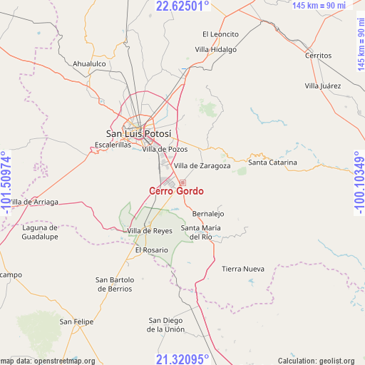
Cerro Gordo GPS coordinates[2]
21° 58' 28.128" North, 100° 48' 23.796" West
| Map corner | latitude | longitude |
|---|---|---|
| Upper-left | 22.62501°, | -101.50974° |
| Center: | 21.97448°, | -100.80661° |
| Lower-right: | 21.32095°, | -100.10349° |
| Map W x H: | 145×145 km | = 90.1×90.1mi |
| max Lat: | 32.7° ⇑16% North |
| Cerro Gordo: | 21.97448° |
| min Lat: | ⇓84% South 14.53588° |
| min Long | Cerro Gordo | max Long |
| -117.105° | -100.80661° | -86.73105° |
| W 28.1%⇐ | ⇒71.9% E |
Elevation
Elevation of Cerro Gordo is 1862 m = 6109 ft, and this is 608.3 m = 1996 ft above average elevation for this country.
| Max E: |
3497 m = 11473 ft | 33.4% |
| Cerro Gordo | 1862 m 6109 ft | |
| Avg. | 1253.7 m = 4113 ft | |
Min E: |
-1 m = -3 ft | 66.6% |
See also: Mexico elevation on elevation.city.
Geographical zone
Cerro Gordo is located in North Torrid zone (between Equator and Tropic of Cancer). Distance of this Northern Tropic circle is 162.6 km =101 mi to North.| Distance of | km | miles | from Cerro Gordo |
|---|---|---|---|
| North Pole | 7563.7 | 4699.9 | to North |
| Arctic Circle | 4957.8 | 3080.6 | to North |
| Tropic Cancer | 162.6 | 101 | to North |
| Equator | 2443.3 | 1518.2 | to South |


Nearby cities:
15 places around Cerro Gordo: (largest is in red/bold)
• Arroyos
13.5 km =8.4 mi,  311°
311°
• El Jaralito
7.3 km =4.5 mi,  348°
348°
• El Mirador
10.1 km =6.3 mi,  209°
209°
• El Terrero Sur
12.8 km =8 mi,  304°
304°
• Emiliano Zapata
12.5 km =7.8 mi,  241°
241°
• Enramadas
10.5 km =6.5 mi,  165°
165°
• La Esperanza
5.7 km =3.5 mi,  49°
49°
• La Pila
9.2 km =5.7 mi,  316°
316°
• La Presa (La Presita)
13.2 km =8.2 mi,  246°
246°
• Laguna de San Vicente
6.3 km =3.9 mi, 239°
• Noria San José
11.6 km =7.2 mi,  325°
325°
• Pardo
11.3 km =7 mi, 206°
• San Lorenzo
9.9 km =6.2 mi,  219°
219°
• Texas
7.2 km =4.5 mi,  117°
117°
• Villa Zaragoza
10.5 km =6.5 mi, 48°
Sources, notices
• [Note1] Compared only with cities in Mexico existing in our database
• [Src1] Map data: © OpenStreetMap contributors (CC-BY-SA)
• [Src2] Other city data from geonames.org with taken over terms of usage.
• [Src3] Geographical zone / Annual Mean Temperature by Robert A. Rohde @ Wikipedia
