Villa Zaragoza geodata
Villa Zaragoza (San Luis Potosí) is a seat of a second-order administrative division; located in Mexico in America/Mexico_City (GMT-6) time zone. With population of 9,915 people, there are 962 cities with bigger population in this country. Compared to other cities in Mexico, 84.4% of cities are located further ↓South; 71.3% of cities are located further →East and 72.5% of cities have lower elevation than Villa Zaragoza. Note1


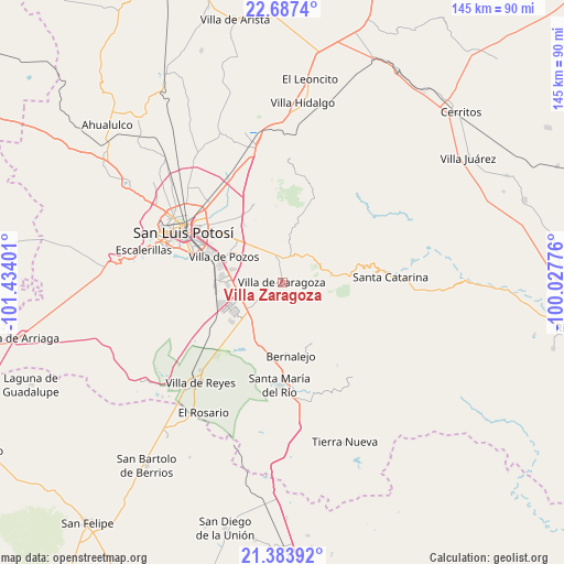
Villa Zaragoza GPS coordinates[2]
22° 2' 13.776" North, 100° 43' 51.168" West
| Map corner | latitude | longitude |
|---|---|---|
| Upper-left | 22.6874°, | -101.43401° |
| Center: | 22.03716°, | -100.73088° |
| Lower-right: | 21.38392°, | -100.02776° |
| Map W x H: | 144.9×144.9 km | = 90×90mi |
| max Lat: | 32.7° ⇑15.6% North |
| Villa Zaragoza: | 22.03716° |
| min Lat: | ⇓84.4% South 14.53588° |
| min Long | Villa Zaragoza | max Long |
| -117.105° | -100.73088° | -86.73105° |
| W 28.7%⇐ | ⇒71.3% E |
Elevation
Elevation of Villa Zaragoza is 1977 m = 6486 ft, and this is 723.3 m = 2373 ft above average elevation for this country.
| Max E: |
3497 m = 11473 ft | 27.5% |
| Villa Zaragoza | 1977 m 6486 ft | |
| Avg. | 1253.7 m = 4113 ft | |
Min E: |
-1 m = -3 ft | 72.5% |
See also: Mexico elevation on elevation.city.
Geographical zone
Villa Zaragoza is located in North Torrid zone (between Equator and Tropic of Cancer). Distance of this Northern Tropic circle is 155.6 km =96.7 mi to North.| Distance of | km | miles | from Villa Zaragoza |
|---|---|---|---|
| North Pole | 7556.8 | 4695.6 | to North |
| Arctic Circle | 4950.9 | 3076.3 | to North |
| Tropic Cancer | 155.6 | 96.7 | to North |
| Equator | 2450.3 | 1522.5 | to South |


Nearby cities:
15 places around Villa Zaragoza: (largest is in red/bold)
• Cerro Gordo
10.5 km =6.5 mi,  228°
228°
• Ciudad Satélite
10.6 km =6.6 mi,  320°
320°
• El Jaralito
9.3 km =5.8 mi,  270°
270°
• La Esperanza
4.8 km =3 mi, 227°
• La Parada del Zarcido
5.7 km =3.5 mi,  33°
33°
• La Pila
14.1 km =8.8 mi, 268°
• Laguna de San Vicente
16.7 km =10.4 mi, 232°
• Laguna de Santa Rita
14.7 km =9.1 mi,  305°
305°
• Noria San José
14.6 km =9.1 mi,  280°
280°
• Panalillo
15.1 km =9.4 mi, 324°
• Portezuelo
17.7 km =11 mi,  326°
326°
• San José de Gómez
9.8 km =6.1 mi,  13°
13°
• Tanque el Jagüey
15.5 km =9.6 mi,  304°
304°
• Texas
10.4 km =6.5 mi,  188°
188°
• Xoconoxtle
7.1 km =4.4 mi,  17°
17°
Sources, notices
• [Note1] Compared only with cities in Mexico existing in our database
• [Src1] Map data: © OpenStreetMap contributors (CC-BY-SA)
• [Src2] Other city data from geonames.org with taken over terms of usage.
• [Src3] Geographical zone / Annual Mean Temperature by Robert A. Rohde @ Wikipedia
