Monte Obscuro geodata
Monte Obscuro (San Luis Potosí) is a populated place; located in Mexico in America/Mexico_City (GMT-6) time zone. With population of 1,771 people, there are 4902 cities with bigger population in this country. Compared to other cities in Mexico, 85.3% of cities are located further ↓South; 73.7% of cities are located further →East and 69.2% of cities have lower elevation than Monte Obscuro. Note1


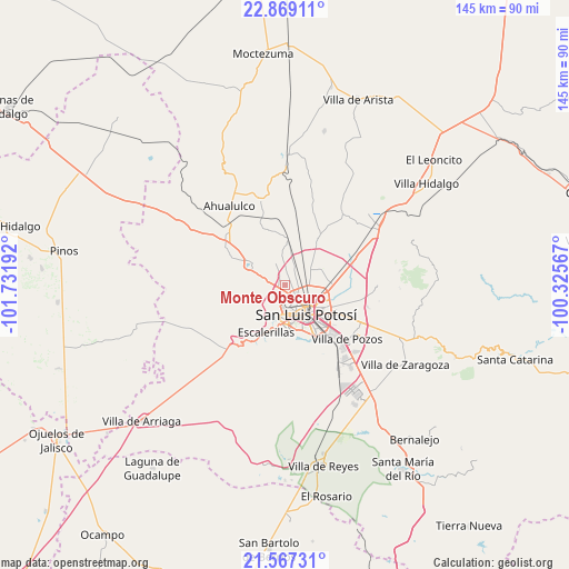
Monte Obscuro GPS coordinates[2]
22° 13' 10.992" North, 101° 1' 43.644" West
| Map corner | latitude | longitude |
|---|---|---|
| Upper-left | 22.86911°, | -101.73192° |
| Center: | 22.21972°, | -101.02879° |
| Lower-right: | 21.56731°, | -100.32567° |
| Map W x H: | 144.7×144.7 km | = 89.9×89.9mi |
| max Lat: | 32.7° ⇑14.7% North |
| Monte Obscuro: | 22.21972° |
| min Lat: | ⇓85.3% South 14.53588° |
| min Long | Monte Obscuro | max Long |
| -117.105° | -101.02879° | -86.73105° |
| W 26.3%⇐ | ⇒73.7% E |
Elevation
Elevation of Monte Obscuro is 1911 m = 6270 ft, and this is 657.3 m = 2156 ft above average elevation for this country.
| Max E: |
3497 m = 11473 ft | 30.8% |
| Monte Obscuro | 1911 m 6270 ft | |
| Avg. | 1253.7 m = 4113 ft | |
Min E: |
-1 m = -3 ft | 69.2% |
See also: Mexico elevation on elevation.city.
Geographical zone
Monte Obscuro is located in North Torrid zone (between Equator and Tropic of Cancer). Distance of this Northern Tropic circle is 135.3 km =84.1 mi to North.| Distance of | km | miles | from Monte Obscuro |
|---|---|---|---|
| North Pole | 7536.5 | 4683 | to North |
| Arctic Circle | 4930.6 | 3063.7 | to North |
| Tropic Cancer | 135.3 | 84.1 | to North |
| Equator | 2470.6 | 1535.2 | to South |


Nearby cities:
15 places around Monte Obscuro: (largest is in red/bold)
• Agua Señora
2.4 km =1.5 mi,  325°
325°
• Capulines
5.3 km =3.3 mi,  205°
205°
• Cerrito de Jaral
3.5 km =2.2 mi,  277°
277°
• Cerrito de Maravillas
3.3 km =2.1 mi,  8°
8°
• Colorada
2.7 km =1.7 mi,  16°
16°
• El Jaralito
3 km =1.9 mi,  223°
223°
• Estanzuela
5.9 km =3.7 mi, 21°
• Fracción la Angostura Norte
2.8 km =1.7 mi,  113°
113°
• La Loma
2.3 km =1.4 mi,  253°
253°
• Los Moreno
4.5 km =2.8 mi,  32°
32°
• Los Retes
5 km =3.1 mi,  312°
312°
• Maravillas
2.8 km =1.7 mi,  41°
41°
• Paisanos
1.9 km =1.2 mi,  202°
202°
• Paso Blanco
4.6 km =2.9 mi, 250°
• Suspiro Picacho
6 km =3.7 mi,  260°
260°
Sources, notices
• [Note1] Compared only with cities in Mexico existing in our database
• [Src1] Map data: © OpenStreetMap contributors (CC-BY-SA)
• [Src2] Other city data from geonames.org with taken over terms of usage.
• [Src3] Geographical zone / Annual Mean Temperature by Robert A. Rohde @ Wikipedia
