Paisanos geodata
Paisanos (San Luis Potosí) is a populated place; located in Mexico in America/Mexico_City (GMT-6) time zone. With population of 1,444 people, there are 5977 cities with bigger population in this country. Compared to other cities in Mexico, 85.2% of cities are located further ↓South; 73.7% of cities are located further →East and 69.7% of cities have lower elevation than Paisanos. Note1


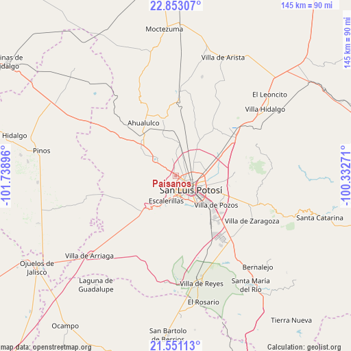
Paisanos GPS coordinates[2]
22° 12' 12.996" North, 101° 2' 8.988" West
| Map corner | latitude | longitude |
|---|---|---|
| Upper-left | 22.85307°, | -101.73896° |
| Center: | 22.20361°, | -101.03583° |
| Lower-right: | 21.55113°, | -100.33271° |
| Map W x H: | 144.8×144.8 km | = 90×90mi |
| max Lat: | 32.7° ⇑14.8% North |
| Paisanos: | 22.20361° |
| min Lat: | ⇓85.2% South 14.53588° |
| min Long | Paisanos | max Long |
| -117.105° | -101.03583° | -86.73105° |
| W 26.3%⇐ | ⇒73.7% E |
Elevation
Elevation of Paisanos is 1919 m = 6296 ft, and this is 665.3 m = 2183 ft above average elevation for this country.
| Max E: |
3497 m = 11473 ft | 30.3% |
| Paisanos | 1919 m 6296 ft | |
| Avg. | 1253.7 m = 4113 ft | |
Min E: |
-1 m = -3 ft | 69.7% |
See also: Mexico elevation on elevation.city.
Geographical zone
Paisanos is located in North Torrid zone (between Equator and Tropic of Cancer). Distance of this Northern Tropic circle is 137.1 km =85.2 mi to North.| Distance of | km | miles | from Paisanos |
|---|---|---|---|
| North Pole | 7538.3 | 4684.1 | to North |
| Arctic Circle | 4932.4 | 3064.9 | to North |
| Tropic Cancer | 137.1 | 85.2 | to North |
| Equator | 2468.8 | 1534 | to South |


Nearby cities:
15 places around Paisanos: (largest is in red/bold)
• Agua Señora
3.8 km =2.4 mi,  350°
350°
• Capulines
3.4 km =2.1 mi,  206°
206°
• Cerrito de Jaral
3.5 km =2.2 mi,  309°
309°
• Cerrito de Maravillas
5.2 km =3.2 mi,  13°
13°
• Colorada
4.7 km =2.9 mi,  18°
18°
• El Jaralito
1.4 km =0.9 mi,  253°
253°
• Fracción la Angostura Norte
3.3 km =2.1 mi,  78°
78°
• Guadalupe Victoria
5.7 km =3.5 mi,  218°
218°
• La Loma
1.9 km =1.2 mi, 306°
• Los Moreno
6.4 km =4 mi,  29°
29°
• Los Retes
5.9 km =3.7 mi,  330°
330°
• Maravillas
4.7 km =2.9 mi, 33°
• Monte Obscuro
1.9 km =1.2 mi, 22°
• Paso Blanco
3.6 km =2.2 mi,  274°
274°
• Suspiro Picacho
5.2 km =3.2 mi,  279°
279°
Sources, notices
• [Note1] Compared only with cities in Mexico existing in our database
• [Src1] Map data: © OpenStreetMap contributors (CC-BY-SA)
• [Src2] Other city data from geonames.org with taken over terms of usage.
• [Src3] Geographical zone / Annual Mean Temperature by Robert A. Rohde @ Wikipedia
