San Isidro (Los Hoyos) geodata
San Isidro (Los Hoyos) (Chihuahua) is a populated place; located in Mexico in America/Chihuahua (GMT-6) time zone. With population of 952 people, there are 9147 cities with bigger population in this country. Compared to other cities in Mexico, 98% of cities are located further ↓South; 93.9% of cities are located further →East and 53.9% of cities have lower elevation than San Isidro (Los Hoyos). Note1
Current local time in San Isidro (Los Hoyos):
05:23 AM, WednesdayDifference from your time zone: hours


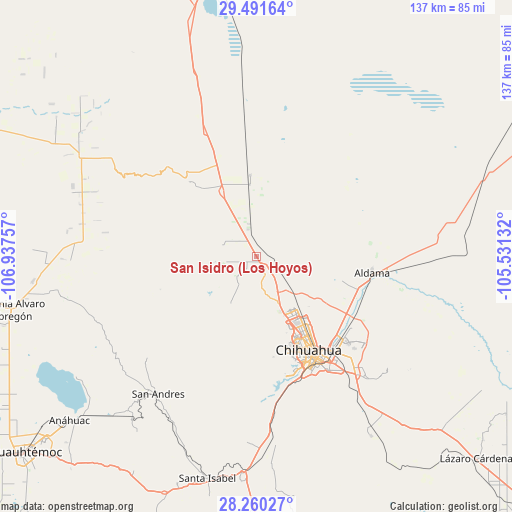
San Isidro (Los Hoyos) GPS coordinates[2]
28° 52' 40.008" North, 106° 14' 3.984" West
| Map corner | latitude | longitude |
|---|---|---|
| Upper-left | 29.49164°, | -106.93757° |
| Center: | 28.87778°, | -106.23444° |
| Lower-right: | 28.26027°, | -105.53132° |
| Map W x H: | 136.9×136.9 km | = 85.1×85.1mi |
| max Lat: | 32.7° ⇑2% North |
| San Isidro (Los Hoyos): | 28.87778° |
| min Lat: | ⇓98% South 14.53588° |
| min Long | San Isidro (Los | max Long |
| -117.105° | -106.23444° | -86.73105° |
| W 6.1%⇐ | ⇒93.9% E |
Elevation
Elevation of San Isidro (Los Hoyos) is 1561 m = 5121 ft, and this is 307.3 m = 1008 ft above average elevation for this country.
| Max E: |
3497 m = 11473 ft | 46.1% |
| San Isidro (Los Hoyos) | 1561 m 5121 ft | |
| Avg. | 1253.7 m = 4113 ft | |
Min E: |
-1 m = -3 ft | 53.9% |
See also: Mexico elevation on elevation.city.
Geographical zone
San Isidro (Los Hoyos) is located in North temperate zone (between Tropic of Cancer and the Arctic Circle). Distance of this Northern Tropic circle is 605 km =375.9 mi to South.| Distance of | km | miles | from San Isidro (Los Hoyos) |
|---|---|---|---|
| North Pole | 6796.2 | 4223 | to North |
| Arctic Circle | 4190.3 | 2603.7 | to North |
| Tropic Cancer | 605 | 375.9 | to South |
| Equator | 3210.9 | 1995.2 | to South |


Nearby cities:
15 places around San Isidro (Los Hoyos): (largest is in red/bold)
• Aldama
31.5 km =19.6 mi,  98°
98°
• Anáhuac
66.5 km =41.3 mi,  228°
228°
• Carretas
74.9 km =46.5 mi,  201°
201°
• Chihuahua
30.5 km =19 mi,  152°
152°
• Colonia Margarita Maza de Juárez
65.5 km =40.7 mi,  258°
258°
• Ejido La Quemada
76.7 km =47.7 mi,  267°
267°
• El Sauz
19.3 km =12 mi,  354°
354°
• Granjas el Venado
64.4 km =40 mi, 257°
• Guadalupe Victoria (Santa Lucía)
76.5 km =47.5 mi, 225°
• La Mesa
28.5 km =17.7 mi,  115°
115°
• Ninguno [CERESO]
41.4 km =25.7 mi,  136°
136°
• San Andrés
45.2 km =28.1 mi,  215°
215°
• San Guillermo
43.7 km =27.2 mi, 137°
• Santa Eulalia
46.2 km =28.7 mi,  132°
132°
• Santa Isabel
61.1 km =38 mi,  192°
192°
Sources, notices
• [Note1] Compared only with cities in Mexico existing in our database
• [Src1] Map data: © OpenStreetMap contributors (CC-BY-SA)
• [Src2] Other city data from geonames.org with taken over terms of usage.
• [Src3] Geographical zone / Annual Mean Temperature by Robert A. Rohde @ Wikipedia
