Santa Isabel geodata
Santa Isabel (Chihuahua) is a seat of a second-order administrative division; located in Mexico in America/Chihuahua (GMT-6) time zone. With population of 1,378 people, there are 6291 cities with bigger population in this country. Compared to other cities in Mexico, 97.6% of cities are located further ↓South; 94% of cities are located further →East and 56.1% of cities have lower elevation than Santa Isabel. Note1


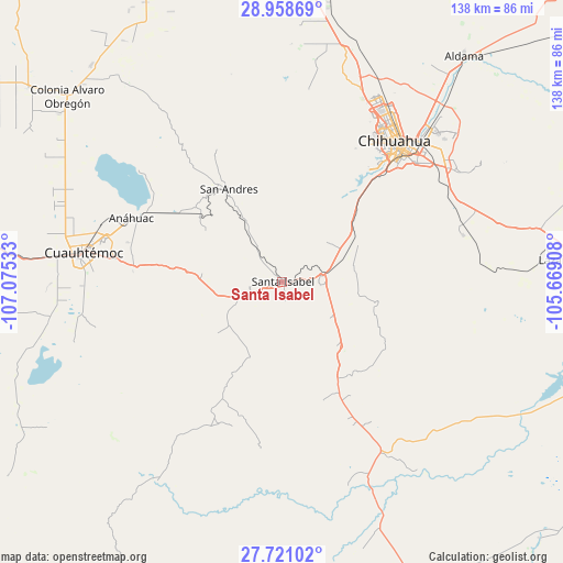
Santa Isabel GPS coordinates[2]
28° 20' 29.976" North, 106° 22' 19.92" West
| Map corner | latitude | longitude |
|---|---|---|
| Upper-left | 28.95869°, | -107.07533° |
| Center: | 28.34166°, | -106.3722° |
| Lower-right: | 27.72102°, | -105.66908° |
| Map W x H: | 137.6×137.6 km | = 85.5×85.5mi |
| max Lat: | 32.7° ⇑2.4% North |
| Santa Isabel: | 28.34166° |
| min Lat: | ⇓97.6% South 14.53588° |
| min Long | Santa Isabel | max Long |
| -117.105° | -106.3722° | -86.73105° |
| W 6%⇐ | ⇒94% E |
Elevation
Elevation of Santa Isabel is 1623 m = 5325 ft, and this is 369.3 m = 1212 ft above average elevation for this country.
| Max E: |
3497 m = 11473 ft | 43.9% |
| Santa Isabel | 1623 m 5325 ft | |
| Avg. | 1253.7 m = 4113 ft | |
Min E: |
-1 m = -3 ft | 56.1% |
See also: Mexico elevation on elevation.city.
Geographical zone
Santa Isabel is located in North temperate zone (between Tropic of Cancer and the Arctic Circle). Distance of this Northern Tropic circle is 545.4 km =338.9 mi to South.| Distance of | km | miles | from Santa Isabel |
|---|---|---|---|
| North Pole | 6855.8 | 4260 | to North |
| Arctic Circle | 4249.9 | 2640.8 | to North |
| Tropic Cancer | 545.4 | 338.9 | to South |
| Equator | 3151.3 | 1958.1 | to South |


Nearby cities:
15 places around Santa Isabel: (largest is in red/bold)
• Anáhuac
39.9 km =24.8 mi,  293°
293°
• Campo Número Dos
57.2 km =35.5 mi,  281°
281°
• Carretas
17 km =10.6 mi,  232°
232°
• Chihuahua
42.8 km =26.6 mi,  40°
40°
• Cuauhtémoc
48.6 km =30.2 mi, 278°
• Cusihuiriachi
46.7 km =29 mi,  255°
255°
• Guadalupe Victoria (Santa Lucía)
41.4 km =25.7 mi, 277°
• La Paz
18.1 km =11.2 mi,  212°
212°
• Ninguno [CERESO]
51.7 km =32.1 mi,  54°
54°
• San Andrés
26.2 km =16.3 mi,  330°
330°
• San Guillermo
51 km =31.7 mi,  57°
57°
• San Lorenzo
23.3 km =14.5 mi, 206°
• Santa Eulalia
55.1 km =34.2 mi, 59°
• Tutuaca
38.4 km =23.9 mi,  204°
204°
• Valentín Gómez Farías
24.9 km =15.5 mi,  236°
236°
Sources, notices
• [Note1] Compared only with cities in Mexico existing in our database
• [Src1] Map data: © OpenStreetMap contributors (CC-BY-SA)
• [Src2] Other city data from geonames.org with taken over terms of usage.
• [Src3] Geographical zone / Annual Mean Temperature by Robert A. Rohde @ Wikipedia
