Carretas geodata
Carretas (Chihuahua) is a seat of a second-order administrative division; located in Mexico in America/Chihuahua (GMT-6) time zone. With population of 726 people, there are 12023 cities with bigger population in this country. Compared to other cities in Mexico, 97.5% of cities are located further ↓South; 94.1% of cities are located further →East and 57.5% of cities have lower elevation than Carretas. Note1


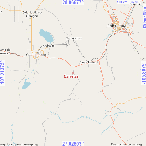
Carretas GPS coordinates[2]
28° 14' 57.12" North, 106° 30' 38.232" West
| Map corner | latitude | longitude |
|---|---|---|
| Upper-left | 28.86677°, | -107.21375° |
| Center: | 28.2492°, | -106.51062° |
| Lower-right: | 27.62803°, | -105.8075° |
| Map W x H: | 137.7×137.7 km | = 85.6×85.6mi |
| max Lat: | 32.7° ⇑2.5% North |
| Carretas: | 28.2492° |
| min Lat: | ⇓97.5% South 14.53588° |
| min Long | Carretas | max Long |
| -117.105° | -106.51062° | -86.73105° |
| W 5.9%⇐ | ⇒94.1% E |
Elevation
Elevation of Carretas is 1676 m = 5499 ft, and this is 422.3 m = 1385 ft above average elevation for this country.
| Max E: |
3497 m = 11473 ft | 42.5% |
| Carretas | 1676 m 5499 ft | |
| Avg. | 1253.7 m = 4113 ft | |
Min E: |
-1 m = -3 ft | 57.5% |
See also: Mexico elevation on elevation.city.
Geographical zone
Carretas is located in North temperate zone (between Tropic of Cancer and the Arctic Circle). Distance of this Northern Tropic circle is 535.1 km =332.5 mi to South.| Distance of | km | miles | from Carretas |
|---|---|---|---|
| North Pole | 6866 | 4266.3 | to North |
| Arctic Circle | 4260.2 | 2647.2 | to North |
| Tropic Cancer | 535.1 | 332.5 | to South |
| Equator | 3141 | 1951.7 | to South |


Nearby cities:
15 places around Carretas: (largest is in red/bold)
• Anáhuac
34.9 km =21.7 mi,  318°
318°
• Campo Número Dos
47.8 km =29.7 mi,  297°
297°
• Chihuahua
59.5 km =37 mi,  43°
43°
• Cuauhtémoc
38.8 km =24.1 mi, 297°
• Cusihuiriachi
31.8 km =19.8 mi,  268°
268°
• Guadalupe Victoria (Santa Lucía)
31.8 km =19.8 mi, 300°
• La Paz
6.3 km =3.9 mi,  142°
142°
• Pedernales
61.4 km =38.2 mi,  287°
287°
• San Andrés
33.1 km =20.6 mi,  1°
1°
• San Francisco de Borja
42.3 km =26.3 mi,  203°
203°
• San Lorenzo
11.1 km =6.9 mi,  162°
162°
• Santa Isabel
17 km =10.6 mi,  52°
52°
• Tutuaca
24.8 km =15.4 mi,  185°
185°
• Valentín Gómez Farías
8 km =5 mi,  243°
243°
• Álamos de Cerro Prieto
58.6 km =36.4 mi,  263°
263°
Sources, notices
• [Note1] Compared only with cities in Mexico existing in our database
• [Src1] Map data: © OpenStreetMap contributors (CC-BY-SA)
• [Src2] Other city data from geonames.org with taken over terms of usage.
• [Src3] Geographical zone / Annual Mean Temperature by Robert A. Rohde @ Wikipedia
