Utatave (Mautillos) geodata
Utatave (Mautillos) (Sinaloa) is a populated place; located in Mexico in America/Mazatlan (GMT-7) time zone. With population of 710 people, there are 12262 cities with bigger population in this country. Compared to other cities in Mexico, 93.1% of cities are located further ↓South; 96.4% of cities are located further →East and 92.5% of cities have higher elevation than Utatave (Mautillos). Note1


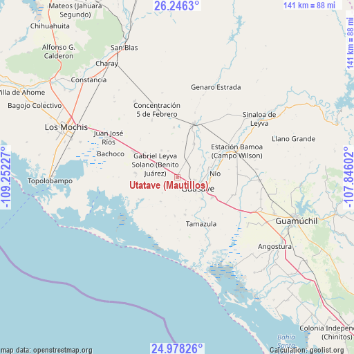
Utatave (Mautillos) GPS coordinates[2]
25° 36' 50.256" North, 108° 32' 56.904" West
| Map corner | latitude | longitude |
|---|---|---|
| Upper-left | 26.2463°, | -109.25227° |
| Center: | 25.61396°, | -108.54914° |
| Lower-right: | 24.97826°, | -107.84602° |
| Map W x H: | 141×141 km | = 87.6×87.6mi |
| max Lat: | 32.7° ⇑6.9% North |
| Utatave (Mautillos): | 25.61396° |
| min Lat: | ⇓93.1% South 14.53588° |
| min Long | Utatave (Mautil | max Long |
| -117.105° | -108.54914° | -86.73105° |
| W 3.6%⇐ | ⇒96.4% E |
Elevation
Elevation of Utatave (Mautillos) is 18 m = 59 ft, and this is 1235.7 m = 4054 ft below average elevation for this country.
| Max E: |
3497 m = 11473 ft | 92.5% |
| Avg. | 1253.7 m = 4113 ft | |
| Utatave (Mautillos) | 18 m = 59 ft | |
Min E: |
-1 m = -3 ft | 7.5% |
See also: Mexico elevation on elevation.city.
Geographical zone
Utatave (Mautillos) is located in North temperate zone (between Tropic of Cancer and the Arctic Circle). Distance of this Northern Tropic circle is 242.1 km =150.4 mi to South.| Distance of | km | miles | from Utatave (Mautillos) |
|---|---|---|---|
| North Pole | 7159.1 | 4448.5 | to North |
| Arctic Circle | 4553.2 | 2829.2 | to North |
| Tropic Cancer | 242.1 | 150.4 | to South |
| Equator | 2848 | 1769.7 | to South |


Nearby cities:
15 places around Utatave (Mautillos): (largest is in red/bold)
• Caimanero
10.7 km =6.6 mi,  94°
94°
• Cinco de Mayo (Agua Blanca)
4.1 km =2.5 mi,  303°
303°
• Colonia 24 de Febrero
10.7 km =6.6 mi,  290°
290°
• Guasave
9.7 km =6 mi,  122°
122°
• La Chuparrosa
8.3 km =5.2 mi,  176°
176°
• La Escalera
8 km =5 mi,  74°
74°
• La Sabanilla (Campo Preciado)
7.4 km =4.6 mi,  148°
148°
• Ladrilleras de Ocoro
10.2 km =6.3 mi,  100°
100°
• Las Moras
10.3 km =6.4 mi,  62°
62°
• Leyva Solano
10.3 km =6.4 mi, 301°
• Los Angeles
6.9 km =4.3 mi, 100°
• Parritas
7.4 km =4.6 mi,  274°
274°
• Ranchito de Inzunza
8.8 km =5.5 mi, 67°
• San Antonio
7.8 km =4.8 mi, 183°
• San Fernando
8.6 km =5.3 mi,  224°
224°
Sources, notices
• [Note1] Compared only with cities in Mexico existing in our database
• [Src1] Map data: © OpenStreetMap contributors (CC-BY-SA)
• [Src2] Other city data from geonames.org with taken over terms of usage.
• [Src3] Geographical zone / Annual Mean Temperature by Robert A. Rohde @ Wikipedia
