Guasave geodata
Guasave (Sinaloa) is a seat of a second-order administrative division; located in Mexico in America/Mazatlan (GMT-7) time zone. With population of 71,196 people, there are 169 cities with bigger population in this country. Compared to other cities in Mexico, 93% of cities are located further ↓South; 96.3% of cities are located further →East and 92.5% of cities have higher elevation than Guasave. Note1


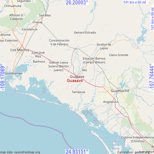
Guasave GPS coordinates[2]
25° 34' 2.82" North, 108° 28' 3.216" West
| Map corner | latitude | longitude |
|---|---|---|
| Upper-left | 26.20003°, | -109.17069° |
| Center: | 25.56745°, | -108.46756° |
| Lower-right: | 24.93151°, | -107.76444° |
| Map W x H: | 141×141 km | = 87.6×87.6mi |
| max Lat: | 32.7° ⇑7% North |
| Guasave: | 25.56745° |
| min Lat: | ⇓93% South 14.53588° |
| min Long | Guasave | max Long |
| -117.105° | -108.46756° | -86.73105° |
| W 3.7%⇐ | ⇒96.3% E |
Elevation
Elevation of Guasave is 18 m = 59 ft, and this is 1235.7 m = 4054 ft below average elevation for this country.
| Max E: |
3497 m = 11473 ft | 92.5% |
| Avg. | 1253.7 m = 4113 ft | |
| Guasave | 18 m = 59 ft | |
Min E: |
-1 m = -3 ft | 7.5% |
See also: Guasave elevation on elevation.city.
Geographical zone
Guasave is located in North temperate zone (between Tropic of Cancer and the Arctic Circle). Distance of this Northern Tropic circle is 236.9 km =147.2 mi to South.| Distance of | km | miles | from Guasave |
|---|---|---|---|
| North Pole | 7164.2 | 4451.6 | to North |
| Arctic Circle | 4558.3 | 2832.4 | to North |
| Tropic Cancer | 236.9 | 147.2 | to South |
| Equator | 2842.8 | 1766.4 | to South |


Nearby cities:
15 places around Guasave: (largest is in red/bold)
• Caimanero
4.9 km =3 mi,  30°
30°
• Chorohui
5.7 km =3.5 mi,  174°
174°
• El Burrión
6.3 km =3.9 mi,  120°
120°
• El Cuitabón
6.7 km =4.2 mi, 30°
• Guasavito
3.6 km =2.2 mi, 116°
• La Escalera
7.3 km =4.5 mi,  356°
356°
• La Sabanilla (Campo Preciado)
4.5 km =2.8 mi,  254°
254°
• Ladrilleras de Ocoro
3.9 km =2.4 mi, 28°
• Las Crucecitas
3.3 km =2.1 mi,  63°
63°
• Los Angeles
4.2 km =2.6 mi,  341°
341°
• Pueblo Viejo
7.3 km =4.5 mi,  44°
44°
• Ranchito de Castro
5.5 km =3.4 mi,  66°
66°
• San Gabriel
4.3 km =2.7 mi,  190°
190°
• San Pedro Guasave
3.4 km =2.1 mi,  161°
161°
• San Pedro Paredes
4.8 km =3 mi,  144°
144°
Sources, notices
• [Note1] Compared only with cities in Mexico existing in our database
• [Src1] Map data: © OpenStreetMap contributors (CC-BY-SA)
• [Src2] Other city data from geonames.org with taken over terms of usage.
• [Src3] Geographical zone / Annual Mean Temperature by Robert A. Rohde @ Wikipedia
