Carricitos geodata
Carricitos (Sinaloa) is a populated place; located in Mexico in America/Mazatlan (GMT-7) time zone. With population of 1,036 people, there are 8418 cities with bigger population in this country. Compared to other cities in Mexico, 95.3% of cities are located further ↓South; 96.9% of cities are located further →East and 89.4% of cities have higher elevation than Carricitos. Note1


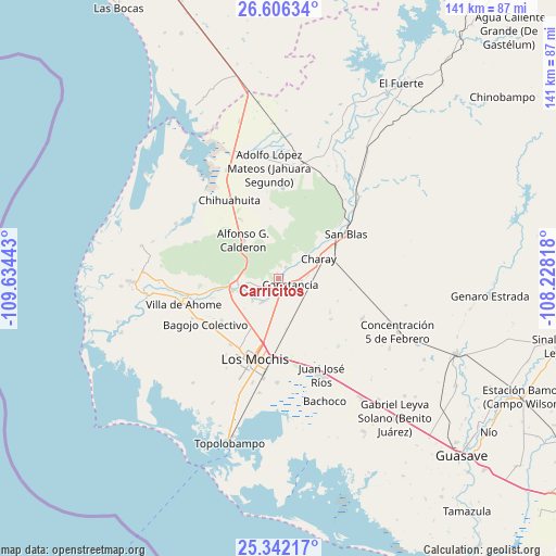
Carricitos GPS coordinates[2]
25° 58' 33.42" North, 108° 55' 52.68" West
| Map corner | latitude | longitude |
|---|---|---|
| Upper-left | 26.60634°, | -109.63443° |
| Center: | 25.97595°, | -108.9313° |
| Lower-right: | 25.34217°, | -108.22818° |
| Map W x H: | 140.6×140.6 km | = 87.4×87.4mi |
| max Lat: | 32.7° ⇑4.7% North |
| Carricitos: | 25.97595° |
| min Lat: | ⇓95.3% South 14.53588° |
| min Long | Carricitos | max Long |
| -117.105° | -108.9313° | -86.73105° |
| W 3.1%⇐ | ⇒96.9% E |
Elevation
Elevation of Carricitos is 26 m = 85 ft, and this is 1227.7 m = 4028 ft below average elevation for this country.
| Max E: |
3497 m = 11473 ft | 89.4% |
| Avg. | 1253.7 m = 4113 ft | |
| Carricitos | 26 m = 85 ft | |
Min E: |
-1 m = -3 ft | 10.6% |
See also: Mexico elevation on elevation.city.
Geographical zone
Carricitos is located in North temperate zone (between Tropic of Cancer and the Arctic Circle). Distance of this Northern Tropic circle is 282.3 km =175.4 mi to South.| Distance of | km | miles | from Carricitos |
|---|---|---|---|
| North Pole | 7118.8 | 4423.4 | to North |
| Arctic Circle | 4512.9 | 2804.2 | to North |
| Tropic Cancer | 282.3 | 175.4 | to South |
| Equator | 2888.3 | 1794.7 | to South |


Nearby cities:
15 places around Carricitos: (largest is in red/bold)
• Benito Juárez (Vinatería)
5.8 km =3.6 mi,  92°
92°
• Camajoa
7.6 km =4.7 mi,  79°
79°
• Constancia
3.5 km =2.2 mi,  115°
115°
• Cuatro Milpas
10.3 km =6.4 mi,  156°
156°
• Dos de Abril
7.3 km =4.5 mi,  187°
187°
• Ejido Antonio Rosales
8.3 km =5.2 mi, 188°
• El Pochotal
9 km =5.6 mi, 76°
• El Ranchito
2.1 km =1.3 mi,  238°
238°
• Higueras de los Natoches
5.1 km =3.2 mi, 244°
• Huepaco
7.1 km =4.4 mi, 82°
• Jahuara Primero (Los Leyva)
3.5 km =2.2 mi,  31°
31°
• Kilómetro 19
9.6 km =6 mi, 122°
• La Palma
9.6 km =6 mi,  48°
48°
• Mochicahui
2.8 km =1.7 mi,  177°
177°
• Taxtes
6.7 km =4.2 mi, 183°
Sources, notices
• [Note1] Compared only with cities in Mexico existing in our database
• [Src1] Map data: © OpenStreetMap contributors (CC-BY-SA)
• [Src2] Other city data from geonames.org with taken over terms of usage.
• [Src3] Geographical zone / Annual Mean Temperature by Robert A. Rohde @ Wikipedia
