El Ranchito geodata
El Ranchito (Sinaloa) is a populated place; located in Mexico in America/Mazatlan (GMT-7) time zone. With population of 597 people, there are 14400 cities with bigger population in this country. Compared to other cities in Mexico, 95.2% of cities are located further ↓South; 96.9% of cities are located further →East and 89.4% of cities have higher elevation than El Ranchito. Note1


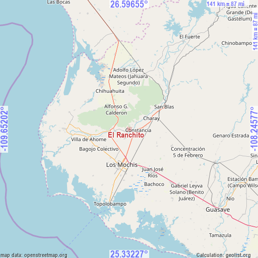
El Ranchito GPS coordinates[2]
25° 57' 57.996" North, 108° 56' 56.004" West
| Map corner | latitude | longitude |
|---|---|---|
| Upper-left | 26.59655°, | -109.65202° |
| Center: | 25.96611°, | -108.94889° |
| Lower-right: | 25.33227°, | -108.24577° |
| Map W x H: | 140.6×140.6 km | = 87.4×87.4mi |
| max Lat: | 32.7° ⇑4.8% North |
| El Ranchito: | 25.96611° |
| min Lat: | ⇓95.2% South 14.53588° |
| min Long | El Ranchito | max Long |
| -117.105° | -108.94889° | -86.73105° |
| W 3.1%⇐ | ⇒96.9% E |
Elevation
Elevation of El Ranchito is 26 m = 85 ft, and this is 1227.7 m = 4028 ft below average elevation for this country.
| Max E: |
3497 m = 11473 ft | 89.4% |
| Avg. | 1253.7 m = 4113 ft | |
| El Ranchito | 26 m = 85 ft | |
Min E: |
-1 m = -3 ft | 10.6% |
See also: Mexico elevation on elevation.city.
Geographical zone
El Ranchito is located in North temperate zone (between Tropic of Cancer and the Arctic Circle). Distance of this Northern Tropic circle is 281.2 km =174.7 mi to South.| Distance of | km | miles | from El Ranchito |
|---|---|---|---|
| North Pole | 7119.9 | 4424.1 | to North |
| Arctic Circle | 4514 | 2804.9 | to North |
| Tropic Cancer | 281.2 | 174.7 | to South |
| Equator | 2887.2 | 1794 | to South |


Nearby cities:
15 places around El Ranchito: (largest is in red/bold)
• Bacaporobampo
9.3 km =5.8 mi,  226°
226°
• Benito Juárez (Vinatería)
7.6 km =4.7 mi,  83°
83°
• Camajoa
9.6 km =6 mi, 75°
• Carricitos
2.1 km =1.3 mi,  58°
58°
• Constancia
5 km =3.1 mi,  95°
95°
• Cuatro Milpas
10.2 km =6.3 mi,  145°
145°
• Dos de Abril
6.2 km =3.9 mi,  172°
172°
• Ejido Antonio Rosales
7.1 km =4.4 mi,  176°
176°
• Higueras de los Natoches
3 km =1.9 mi,  249°
249°
• Huepaco
9.1 km =5.7 mi, 77°
• Jahuara Primero (Los Leyva)
5.4 km =3.4 mi,  41°
41°
• Mochicahui
2.5 km =1.6 mi,  131°
131°
• Nuevo San Miguel
10.5 km =6.5 mi,  268°
268°
• San Miguel Zapotitlan
10 km =6.2 mi,  258°
258°
• Taxtes
5.7 km =3.5 mi, 166°
Sources, notices
• [Note1] Compared only with cities in Mexico existing in our database
• [Src1] Map data: © OpenStreetMap contributors (CC-BY-SA)
• [Src2] Other city data from geonames.org with taken over terms of usage.
• [Src3] Geographical zone / Annual Mean Temperature by Robert A. Rohde @ Wikipedia
