Paso de Cuarenta geodata
Paso de Cuarenta (Jalisco) is a populated place; located in Mexico in America/Mexico_City (GMT-6) time zone. With population of 3,727 people, there are 2464 cities with bigger population in this country. Compared to other cities in Mexico, 81.4% of cities are located further ↓South; 79.4% of cities are located further →East and 70.7% of cities have lower elevation than Paso de Cuarenta. Note1


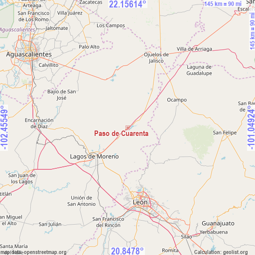
Paso de Cuarenta GPS coordinates[2]
21° 30' 12.384" North, 101° 45' 8.496" West
| Map corner | latitude | longitude |
|---|---|---|
| Upper-left | 22.15614°, | -102.45549° |
| Center: | 21.50344°, | -101.75236° |
| Lower-right: | 20.8478°, | -101.04924° |
| Map W x H: | 145.5×145.5 km | = 90.4×90.4mi |
| max Lat: | 32.7° ⇑18.6% North |
| Paso de Cuarenta: | 21.50344° |
| min Lat: | ⇓81.4% South 14.53588° |
| min Long | Paso de Cuarent | max Long |
| -117.105° | -101.75236° | -86.73105° |
| W 20.6%⇐ | ⇒79.4% E |
Elevation
Elevation of Paso de Cuarenta is 1939 m = 6362 ft, and this is 685.3 m = 2248 ft above average elevation for this country.
| Max E: |
3497 m = 11473 ft | 29.3% |
| Paso de Cuarenta | 1939 m 6362 ft | |
| Avg. | 1253.7 m = 4113 ft | |
Min E: |
-1 m = -3 ft | 70.7% |
See also: Mexico elevation on elevation.city.
Geographical zone
Paso de Cuarenta is located in North Torrid zone (between Equator and Tropic of Cancer). Distance of this Northern Tropic circle is 215 km =133.6 mi to North.| Distance of | km | miles | from Paso de Cuarenta |
|---|---|---|---|
| North Pole | 7616.1 | 4732.4 | to North |
| Arctic Circle | 5010.2 | 3113.2 | to North |
| Tropic Cancer | 215 | 133.6 | to North |
| Equator | 2391 | 1485.7 | to South |


Nearby cities:
15 places around Paso de Cuarenta: (largest is in red/bold)
• Buenavista (San Miguel)
25.2 km =15.7 mi,  240°
240°
• Chipinque de Arriba
17.8 km =11.1 mi, 243°
• Comanja de Corona
20.2 km =12.6 mi,  168°
168°
• Dieciocho de Marzo
5.3 km =3.3 mi, 244°
• El Bajío (La Laguna)
24.7 km =15.3 mi, 236°
• El Ojuelo
14.3 km =8.9 mi,  217°
217°
• El Puesto
25.8 km =16 mi,  301°
301°
• El Refugio (El Maguey)
9.5 km =5.9 mi,  207°
207°
• Granadillas (La Colonia)
20.7 km =12.9 mi,  228°
228°
• La Orilla del Agua
24.6 km =15.3 mi, 237°
• Lagos de Moreno
25.2 km =15.7 mi, 229°
• Matanzas
17.6 km =10.9 mi,  34°
34°
• Primero de Mayo (Chupaderos)
8.8 km =5.5 mi, 241°
• San Antonio de Buenavista
12.9 km =8 mi,  266°
266°
• San Pedro de Ibarra
22 km =13.7 mi,  95°
95°
Sources, notices
• [Note1] Compared only with cities in Mexico existing in our database
• [Src1] Map data: © OpenStreetMap contributors (CC-BY-SA)
• [Src2] Other city data from geonames.org with taken over terms of usage.
• [Src3] Geographical zone / Annual Mean Temperature by Robert A. Rohde @ Wikipedia
