Ventana geodata
Ventana (Coahuila) is a populated place; located in Mexico in America/Monterrey (GMT-6) time zone. With population of 1,966 people, there are 4435 cities with bigger population in this country. Compared to other cities in Mexico, 92.2% of cities are located further ↓South; 88.2% of cities are located further →East and 54.9% of cities have higher elevation than Ventana. Note1


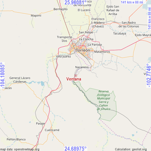
Ventana GPS coordinates[2]
25° 19' 37.02" North, 103° 28' 39.792" West
| Map corner | latitude | longitude |
|---|---|---|
| Upper-left | 25.96081°, | -104.18085° |
| Center: | 25.32695°, | -103.47772° |
| Lower-right: | 24.68975°, | -102.7746° |
| Map W x H: | 141.3×141.3 km | = 87.8×87.8mi |
| max Lat: | 32.7° ⇑7.8% North |
| Ventana: | 25.32695° |
| min Lat: | ⇓92.2% South 14.53588° |
| min Long | Ventana | max Long |
| -117.105° | -103.47772° | -86.73105° |
| W 11.8%⇐ | ⇒88.2% E |
Elevation
Elevation of Ventana is 1201 m = 3940 ft, and this is 52.7 m = 173 ft below average elevation for this country.
| Max E: |
3497 m = 11473 ft | 54.9% |
| Avg. | 1253.7 m = 4113 ft | |
| Ventana | 1201 m = 3940 ft | |
Min E: |
-1 m = -3 ft | 45.1% |
See also: Mexico elevation on elevation.city.
Geographical zone
Ventana is located in North temperate zone (between Tropic of Cancer and the Arctic Circle). Distance of this Northern Tropic circle is 210.2 km =130.6 mi to South.| Distance of | km | miles | from Ventana |
|---|---|---|---|
| North Pole | 7191 | 4468.3 | to North |
| Arctic Circle | 4585.1 | 2849 | to North |
| Tropic Cancer | 210.2 | 130.6 | to South |
| Equator | 2816.1 | 1749.8 | to South |


Nearby cities:
15 places around Ventana: (largest is in red/bold)
• Boquilla de las Perlas
19 km =11.8 mi,  89°
89°
• El Huarache (El Guarache)
21.5 km =13.4 mi,  357°
357°
• Jalisco
12.9 km =8 mi,  163°
163°
• Las Cuevas
20.4 km =12.7 mi,  339°
339°
• Las Isabeles
20.5 km =12.7 mi, 336°
• Las Palomas
15.1 km =9.4 mi,  70°
70°
• Las Piedras
22 km =13.7 mi,  332°
332°
• Nazareno
9.9 km =6.2 mi,  35°
35°
• Nuevo Mieleras
19.1 km =11.9 mi,  48°
48°
• Picardías
0.9 km =0.6 mi,  252°
252°
• San Isidro
14.8 km =9.2 mi, 72°
• San José de Zaragoza
11.1 km =6.9 mi,  174°
174°
• Villa Juárez
21.7 km =13.5 mi, 327°
• Villa de Guadalupe
20.9 km =13 mi, 356°
• Álvaro Obregón
21 km =13 mi,  352°
352°
Sources, notices
• [Note1] Compared only with cities in Mexico existing in our database
• [Src1] Map data: © OpenStreetMap contributors (CC-BY-SA)
• [Src2] Other city data from geonames.org with taken over terms of usage.
• [Src3] Geographical zone / Annual Mean Temperature by Robert A. Rohde @ Wikipedia
