Nazareno geodata
Nazareno (Durango) is a populated place; located in Mexico in America/Monterrey (GMT-6) time zone. With population of 7,515 people, there are 1243 cities with bigger population in this country. Compared to other cities in Mexico, 92.4% of cities are located further ↓South; 87.9% of cities are located further →East and 55.6% of cities have higher elevation than Nazareno. Note1


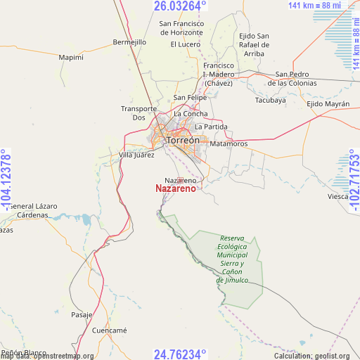
Nazareno GPS coordinates[2]
25° 23' 56.976" North, 103° 25' 14.34" West
| Map corner | latitude | longitude |
|---|---|---|
| Upper-left | 26.03264°, | -104.12378° |
| Center: | 25.39916°, | -103.42065° |
| Lower-right: | 24.76234°, | -102.71753° |
| Map W x H: | 141.2×141.2 km | = 87.7×87.7mi |
| max Lat: | 32.7° ⇑7.6% North |
| Nazareno: | 25.39916° |
| min Lat: | ⇓92.4% South 14.53588° |
| min Long | Nazareno | max Long |
| -117.105° | -103.42065° | -86.73105° |
| W 12.1%⇐ | ⇒87.9% E |
Elevation
Elevation of Nazareno is 1176 m = 3858 ft, and this is 77.7 m = 255 ft below average elevation for this country.
| Max E: |
3497 m = 11473 ft | 55.6% |
| Avg. | 1253.7 m = 4113 ft | |
| Nazareno | 1176 m = 3858 ft | |
Min E: |
-1 m = -3 ft | 44.4% |
See also: Mexico elevation on elevation.city.
Geographical zone
Nazareno is located in North temperate zone (between Tropic of Cancer and the Arctic Circle). Distance of this Northern Tropic circle is 218.2 km =135.6 mi to South.| Distance of | km | miles | from Nazareno |
|---|---|---|---|
| North Pole | 7182.9 | 4463.2 | to North |
| Arctic Circle | 4577.1 | 2844.1 | to North |
| Tropic Cancer | 218.2 | 135.6 | to South |
| Equator | 2824.1 | 1754.8 | to South |


Nearby cities:
15 places around Nazareno: (largest is in red/bold)
• Boquilla de las Perlas
15.4 km =9.6 mi,  120°
120°
• El Huarache (El Guarache)
15 km =9.3 mi,  333°
333°
• La Perla
12.9 km =8 mi,  32°
32°
• Las Cuevas
17 km =10.6 mi,  310°
310°
• Las Mieleras
15.4 km =9.6 mi,  89°
89°
• Las Palomas
9 km =5.6 mi,  109°
109°
• Nuevo Mieleras
9.7 km =6 mi,  61°
61°
• Picardías
10.6 km =6.6 mi,  218°
218°
• Rancho Alegre
14.8 km =9.2 mi,  39°
39°
• San Isidro
9.1 km =5.7 mi, 112°
• Santo Niño Aguanaval
14.7 km =9.1 mi,  75°
75°
• Torreón
16.1 km =10 mi,  0°
0°
• Ventana
9.9 km =6.2 mi, 215°
• Villa de Guadalupe
14.5 km =9 mi, 331°
• Álvaro Obregón
15.3 km =9.5 mi, 326°
Sources, notices
• [Note1] Compared only with cities in Mexico existing in our database
• [Src1] Map data: © OpenStreetMap contributors (CC-BY-SA)
• [Src2] Other city data from geonames.org with taken over terms of usage.
• [Src3] Geographical zone / Annual Mean Temperature by Robert A. Rohde @ Wikipedia
