Mayran geodata
Mayran (Coahuila) is a populated place; located in Mexico in America/Monterrey (GMT-6) time zone. With population of 1,507 people, there are 5723 cities with bigger population in this country. Compared to other cities in Mexico, 93.5% of cities are located further ↓South; 85.2% of cities are located further →East and 58.2% of cities have higher elevation than Mayran. Note1


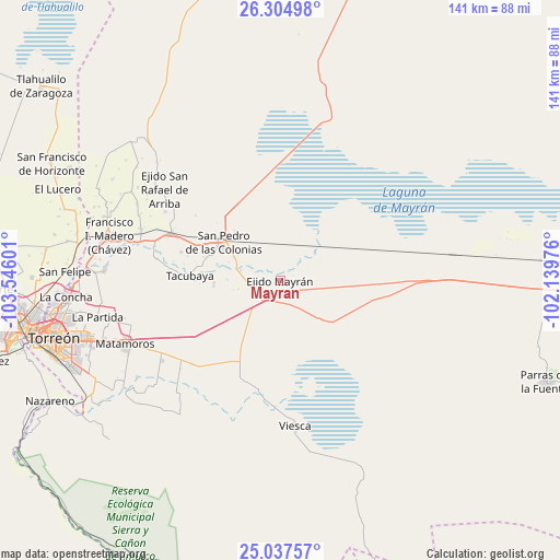
Mayran GPS coordinates[2]
25° 40' 22.656" North, 102° 50' 34.368" West
| Map corner | latitude | longitude |
|---|---|---|
| Upper-left | 26.30498°, | -103.54601° |
| Center: | 25.67296°, | -102.84288° |
| Lower-right: | 25.03757°, | -102.13976° |
| Map W x H: | 140.9×140.9 km | = 87.6×87.6mi |
| max Lat: | 32.7° ⇑6.5% North |
| Mayran: | 25.67296° |
| min Lat: | ⇓93.5% South 14.53588° |
| min Long | Mayran | max Long |
| -117.105° | -102.84288° | -86.73105° |
| W 14.8%⇐ | ⇒85.2% E |
Elevation
Elevation of Mayran is 1096 m = 3596 ft, and this is 157.7 m = 517 ft below average elevation for this country.
| Max E: |
3497 m = 11473 ft | 58.2% |
| Avg. | 1253.7 m = 4113 ft | |
| Mayran | 1096 m = 3596 ft | |
Min E: |
-1 m = -3 ft | 41.8% |
See also: Mexico elevation on elevation.city.
Geographical zone
Mayran is located in North temperate zone (between Tropic of Cancer and the Arctic Circle). Distance of this Northern Tropic circle is 248.6 km =154.5 mi to South.| Distance of | km | miles | from Mayran |
|---|---|---|---|
| North Pole | 7152.5 | 4444.4 | to North |
| Arctic Circle | 4546.6 | 2825.1 | to North |
| Tropic Cancer | 248.6 | 154.5 | to South |
| Equator | 2854.6 | 1773.8 | to South |


Nearby cities:
15 places around Mayran: (largest is in red/bold)
• Bolívar
20.5 km =12.7 mi,  303°
303°
• Concordia
29.9 km =18.6 mi,  293°
293°
• Ejido Emiliano Zapata
22.9 km =14.2 mi,  206°
206°
• El Nilo
12.1 km =7.5 mi, 303°
• Ignacio Zaragoza
13.6 km =8.5 mi,  283°
283°
• San Esteban de Abajo
16.3 km =10.1 mi, 284°
• San Felipe
13.3 km =8.3 mi,  271°
271°
• San Ignacio
25.8 km =16 mi, 285°
• San Marcos
16.7 km =10.4 mi, 267°
• San Miguel
11.2 km =7 mi, 285°
• San Pablo
24 km =14.9 mi, 284°
• San Pedro
16.9 km =10.5 mi, 303°
• San Rafael de Abajo
16.7 km =10.4 mi,  264°
264°
• Santa Elena
18.8 km =11.7 mi, 276°
• Tacubaya
22.7 km =14.1 mi, 272°
Sources, notices
• [Note1] Compared only with cities in Mexico existing in our database
• [Src1] Map data: © OpenStreetMap contributors (CC-BY-SA)
• [Src2] Other city data from geonames.org with taken over terms of usage.
• [Src3] Geographical zone / Annual Mean Temperature by Robert A. Rohde @ Wikipedia
