Zirahuén geodata
Zirahuén (Michoacán) is a populated place; located in Mexico in America/Mexico_City (GMT-6) time zone. With population of 2,942 people, there are 3035 cities with bigger population in this country. Compared to other cities in Mexico, 55% of cities are located further ↑North; 79.3% of cities are located further →East and 78.3% of cities have lower elevation than Zirahuén. Note1


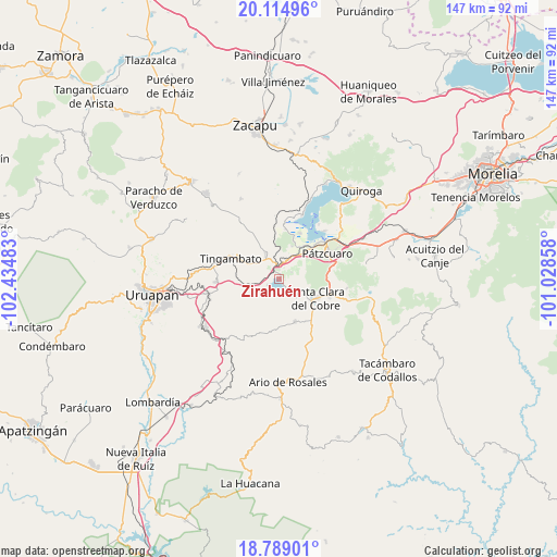
Zirahuén GPS coordinates[2]
19° 27' 12.024" North, 101° 43' 54.12" West
| Map corner | latitude | longitude |
|---|---|---|
| Upper-left | 20.11496°, | -102.43483° |
| Center: | 19.45334°, | -101.7317° |
| Lower-right: | 18.78901°, | -101.02858° |
| Map W x H: | 147.4×147.4 km | = 91.6×91.6mi |
| max Lat: | 32.7° ⇑55% North |
| Zirahuén: | 19.45334° |
| min Lat: | ⇓45% South 14.53588° |
| min Long | Zirahuén | max Long |
| -117.105° | -101.7317° | -86.73105° |
| W 20.7%⇐ | ⇒79.3% E |
Elevation
Elevation of Zirahuén is 2094 m = 6870 ft, and this is 840.3 m = 2757 ft above average elevation for this country.
| Max E: |
3497 m = 11473 ft | 21.7% |
| Zirahuén | 2094 m 6870 ft | |
| Avg. | 1253.7 m = 4113 ft | |
Min E: |
-1 m = -3 ft | 78.3% |
See also: Mexico elevation on elevation.city.
Geographical zone
Zirahuén is located in North Torrid zone (between Equator and Tropic of Cancer). Distance of this Northern Tropic circle is 442.9 km =275.2 mi to North.| Distance of | km | miles | from Zirahuén |
|---|---|---|---|
| North Pole | 7844.1 | 4874.1 | to North |
| Arctic Circle | 5238.2 | 3254.9 | to North |
| Tropic Cancer | 442.9 | 275.2 | to North |
| Equator | 2163 | 1344 | to South |


Nearby cities:
15 places around Zirahuén: (largest is in red/bold)
• Ajuno
6.7 km =4.2 mi,  8°
8°
• Arocutín
12.1 km =7.5 mi,  18°
18°
• Chapa
10.7 km =6.6 mi,  139°
139°
• Cuitzitán
13.3 km =8.3 mi, 139°
• Jarácuaro
13.2 km =8.2 mi,  25°
25°
• La Escondida
12.8 km =8 mi,  277°
277°
• Parahuén
12 km =7.5 mi,  159°
159°
• San Miguel Charahuén
3.7 km =2.3 mi,  61°
61°
• San Miguel Nocutzepo
9.2 km =5.7 mi, 22°
• San Pedro Pareo
10.9 km =6.8 mi,  36°
36°
• Santa Ana Chapitiro
11.6 km =7.2 mi,  45°
45°
• Santa Clara del Cobre
11 km =6.8 mi,  118°
118°
• Santa María Huiramangaro (San Juan Tumbio)
7.5 km =4.7 mi,  332°
332°
• Tócuaro
10.3 km =6.4 mi, 22°
• Uricho
13.2 km =8.2 mi, 7°
Sources, notices
• [Note1] Compared only with cities in Mexico existing in our database
• [Src1] Map data: © OpenStreetMap contributors (CC-BY-SA)
• [Src2] Other city data from geonames.org with taken over terms of usage.
• [Src3] Geographical zone / Annual Mean Temperature by Robert A. Rohde @ Wikipedia
