La Escondida geodata
La Escondida (Michoacán) is a populated place; located in Mexico in America/Mexico_City (GMT-6) time zone. With population of 740 people, there are 11812 cities with bigger population in this country. Compared to other cities in Mexico, 54.7% of cities are located further ↑North; 80% of cities are located further →East and 71% of cities have lower elevation than La Escondida. Note1


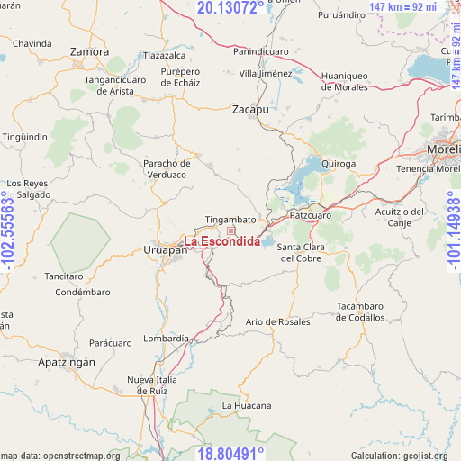
La Escondida GPS coordinates[2]
19° 28' 9.012" North, 101° 51' 9" West
| Map corner | latitude | longitude |
|---|---|---|
| Upper-left | 20.13072°, | -102.55563° |
| Center: | 19.46917°, | -101.8525° |
| Lower-right: | 18.80491°, | -101.14938° |
| Map W x H: | 147.4×147.4 km | = 91.6×91.6mi |
| max Lat: | 32.7° ⇑54.7% North |
| La Escondida: | 19.46917° |
| min Lat: | ⇓45.3% South 14.53588° |
| min Long | La Escondida | max Long |
| -117.105° | -101.8525° | -86.73105° |
| W 20%⇐ | ⇒80% E |
Elevation
Elevation of La Escondida is 1945 m = 6381 ft, and this is 691.3 m = 2268 ft above average elevation for this country.
| Max E: |
3497 m = 11473 ft | 29% |
| La Escondida | 1945 m 6381 ft | |
| Avg. | 1253.7 m = 4113 ft | |
Min E: |
-1 m = -3 ft | 71% |
See also: Mexico elevation on elevation.city.
Geographical zone
La Escondida is located in North Torrid zone (between Equator and Tropic of Cancer). Distance of this Northern Tropic circle is 441.2 km =274.1 mi to North.| Distance of | km | miles | from La Escondida |
|---|---|---|---|
| North Pole | 7842.3 | 4873 | to North |
| Arctic Circle | 5236.4 | 3253.7 | to North |
| Tropic Cancer | 441.2 | 274.1 | to North |
| Equator | 2164.8 | 1345.1 | to South |


Nearby cities:
15 places around La Escondida: (largest is in red/bold)
• Ajuno
14.4 km =8.9 mi,  70°
70°
• Caracha
8.2 km =5.1 mi,  242°
242°
• Comachuén
12.6 km =7.8 mi,  334°
334°
• La Florida
17 km =10.6 mi,  184°
184°
• Patuán
10.9 km =6.8 mi,  218°
218°
• Pichátaro
12.5 km =7.8 mi,  22°
22°
• San Andrés Coru
9.7 km =6 mi,  268°
268°
• San Miguel Charahuén
15.9 km =9.9 mi,  90°
90°
• Santa María Huiramangaro (San Juan Tumbio)
10.4 km =6.5 mi,  61°
61°
• Taretán
16.5 km =10.3 mi,  204°
204°
• Tingambato
3.6 km =2.2 mi,  358°
358°
• Toreo Bajo (El Toreo Bajo)
16.2 km =10.1 mi,  260°
260°
• Turícuaro
14.4 km =8.9 mi,  321°
321°
• Zirahuén
12.8 km =8 mi,  97°
97°
• Zirimícuaro
13 km =8.1 mi, 238°
Sources, notices
• [Note1] Compared only with cities in Mexico existing in our database
• [Src1] Map data: © OpenStreetMap contributors (CC-BY-SA)
• [Src2] Other city data from geonames.org with taken over terms of usage.
• [Src3] Geographical zone / Annual Mean Temperature by Robert A. Rohde @ Wikipedia
