Jarácuaro geodata
Jarácuaro (Michoacán) is a populated place; located in Mexico in America/Mexico_City (GMT-6) time zone. With population of 2,817 people, there are 3151 cities with bigger population in this country. Compared to other cities in Mexico, 52.9% of cities are located further ↑North; 78.8% of cities are located further →East and 77% of cities have lower elevation than Jarácuaro. Note1


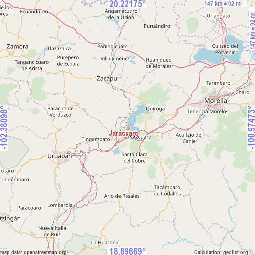
Jarácuaro GPS coordinates[2]
19° 33' 38.088" North, 101° 40' 40.26" West
| Map corner | latitude | longitude |
|---|---|---|
| Upper-left | 20.22175°, | -102.38098° |
| Center: | 19.56058°, | -101.67785° |
| Lower-right: | 18.89669°, | -100.97473° |
| Map W x H: | 147.3×147.3 km | = 91.5×91.5mi |
| max Lat: | 32.7° ⇑52.9% North |
| Jarácuaro: | 19.56058° |
| min Lat: | ⇓47.1% South 14.53588° |
| min Long | Jarácuaro | max Long |
| -117.105° | -101.67785° | -86.73105° |
| W 21.2%⇐ | ⇒78.8% E |
Elevation
Elevation of Jarácuaro is 2069 m = 6788 ft, and this is 815.3 m = 2675 ft above average elevation for this country.
| Max E: |
3497 m = 11473 ft | 23% |
| Jarácuaro | 2069 m 6788 ft | |
| Avg. | 1253.7 m = 4113 ft | |
Min E: |
-1 m = -3 ft | 77% |
See also: Mexico elevation on elevation.city.
Geographical zone
Jarácuaro is located in North Torrid zone (between Equator and Tropic of Cancer). Distance of this Northern Tropic circle is 431 km =267.8 mi to North.| Distance of | km | miles | from Jarácuaro |
|---|---|---|---|
| North Pole | 7832.1 | 4866.6 | to North |
| Arctic Circle | 5226.2 | 3247.4 | to North |
| Tropic Cancer | 431 | 267.8 | to North |
| Equator | 2174.9 | 1351.4 | to South |


Nearby cities:
15 places around Jarácuaro: (largest is in red/bold)
• Ajuno
7.1 km =4.4 mi,  221°
221°
• Arocutín
1.9 km =1.2 mi,  257°
257°
• Cucuchucho
5.5 km =3.4 mi,  63°
63°
• Erongarícuaro
5.5 km =3.4 mi,  304°
304°
• Huecorio
5.3 km =3.3 mi,  117°
117°
• Ihuatzio
6.5 km =4 mi,  84°
84°
• Janitzio
3.1 km =1.9 mi, 62°
• Napízaro
4.4 km =2.7 mi,  338°
338°
• Puácuaro
4.7 km =2.9 mi,  4°
4°
• Pátzcuaro
8.8 km =5.5 mi, 124°
• San Miguel Nocutzepo
4 km =2.5 mi,  212°
212°
• San Pedro Pareo
3.2 km =2 mi,  166°
166°
• Santa Ana Chapitiro
4.7 km =2.9 mi,  145°
145°
• Tócuaro
2.9 km =1.8 mi, 216°
• Uricho
4.2 km =2.6 mi,  286°
286°
Sources, notices
• [Note1] Compared only with cities in Mexico existing in our database
• [Src1] Map data: © OpenStreetMap contributors (CC-BY-SA)
• [Src2] Other city data from geonames.org with taken over terms of usage.
• [Src3] Geographical zone / Annual Mean Temperature by Robert A. Rohde @ Wikipedia
