Ixtapa geodata
Ixtapa (Guerrero) is a populated place; located in Mexico in America/Mexico_City (GMT-6) time zone. With population of 8,992 people, there are 1057 cities with bigger population in this country. Compared to other cities in Mexico, 81.6% of cities are located further ↑North; 78.5% of cities are located further →East and 97% of cities have higher elevation than Ixtapa. Note1


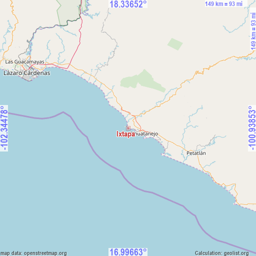
Ixtapa GPS coordinates[2]
17° 40' 4.152" North, 101° 38' 29.94" West
| Map corner | latitude | longitude |
|---|---|---|
| Upper-left | 18.33652°, | -102.34478° |
| Center: | 17.66782°, | -101.64165° |
| Lower-right: | 16.99663°, | -100.93853° |
| Map W x H: | 149×149 km | = 92.6×92.6mi |
| max Lat: | 32.7° ⇑81.6% North |
| Ixtapa: | 17.66782° |
| min Lat: | ⇓18.4% South 14.53588° |
| min Long | Ixtapa | max Long |
| -117.105° | -101.64165° | -86.73105° |
| W 21.5%⇐ | ⇒78.5% E |
Elevation
Elevation of Ixtapa is 10 m = 33 ft, and this is 1243.7 m = 4080 ft below average elevation for this country.
| Max E: |
3497 m = 11473 ft | 97% |
| Avg. | 1253.7 m = 4113 ft | |
| Ixtapa | 10 m = 33 ft | |
Min E: |
-1 m = -3 ft | 3% |
See also: Mexico elevation on elevation.city.
Geographical zone
Ixtapa is located in North Torrid zone (between Equator and Tropic of Cancer). Distance of this Northern Tropic circle is 641.4 km =398.5 mi to North.| Distance of | km | miles | from Ixtapa |
|---|---|---|---|
| North Pole | 8042.6 | 4997.4 | to North |
| Arctic Circle | 5436.7 | 3378.2 | to North |
| Tropic Cancer | 641.4 | 398.5 | to North |
| Equator | 1964.5 | 1220.7 | to South |


Nearby cities:
15 places around Ixtapa: (largest is in red/bold)
• Barbulillas
3.9 km =2.4 mi,  60°
60°
• Barrio Nuevo
5.9 km =3.7 mi,  5°
5°
• Colonia Aeropuerto
20.1 km =12.5 mi,  105°
105°
• El Coacoyul
17.9 km =11.1 mi,  100°
100°
• El Posquelite
8 km =5 mi,  84°
84°
• Ixtapa-Zihuatanejo
9.9 km =6.2 mi, 105°
• La Salitrera
7 km =4.3 mi,  35°
35°
• Lagunillas
18.9 km =11.7 mi,  337°
337°
• Los Almendros
22.3 km =13.9 mi, 106°
• Los Reyes (Las Chiveras)
16.2 km =10.1 mi, 100°
• Pantla
7.9 km =4.9 mi,  4°
4°
• San José Ixtapa (Barrio Viejo)
4.5 km =2.8 mi,  31°
31°
• San Miguelito
21.9 km =13.6 mi, 99°
• Troncones
14.9 km =9.3 mi,  326°
326°
• Villa Hermosa (Las Pozas)
19 km =11.8 mi, 101°
Sources, notices
• [Note1] Compared only with cities in Mexico existing in our database
• [Src1] Map data: © OpenStreetMap contributors (CC-BY-SA)
• [Src2] Other city data from geonames.org with taken over terms of usage.
• [Src3] Geographical zone / Annual Mean Temperature by Robert A. Rohde @ Wikipedia
