Vista Hermosa geodata
Vista Hermosa (Jalisco) is a populated place; located in Mexico in America/Mexico_City (GMT-6) time zone. With population of 3,490 people, there are 2620 cities with bigger population in this country. Compared to other cities in Mexico, 50.3% of cities are located further ↓South; 87.4% of cities are located further →East and 55.5% of cities have higher elevation than Vista Hermosa. Note1


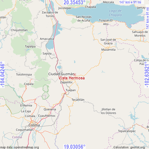
Vista Hermosa GPS coordinates[2]
19° 41' 38.076" North, 103° 20' 21.588" West
| Map corner | latitude | longitude |
|---|---|---|
| Upper-left | 20.35453°, | -104.04246° |
| Center: | 19.69391°, | -103.33933° |
| Lower-right: | 19.03056°, | -102.63621° |
| Map W x H: | 147.2×147.2 km | = 91.5×91.5mi |
| max Lat: | 32.7° ⇑49.7% North |
| Vista Hermosa: | 19.69391° |
| min Lat: | ⇓50.3% South 14.53588° |
| min Long | Vista Hermosa | max Long |
| -117.105° | -103.33933° | -86.73105° |
| W 12.6%⇐ | ⇒87.4% E |
Elevation
Elevation of Vista Hermosa is 1177 m = 3862 ft, and this is 76.7 m = 252 ft below average elevation for this country.
| Max E: |
3497 m = 11473 ft | 55.5% |
| Avg. | 1253.7 m = 4113 ft | |
| Vista Hermosa | 1177 m = 3862 ft | |
Min E: |
-1 m = -3 ft | 44.5% |
See also: Mexico elevation on elevation.city.
Geographical zone
Vista Hermosa is located in North Torrid zone (between Equator and Tropic of Cancer). Distance of this Northern Tropic circle is 416.2 km =258.6 mi to North.| Distance of | km | miles | from Vista Hermosa |
|---|---|---|---|
| North Pole | 7817.3 | 4857.4 | to North |
| Arctic Circle | 5211.4 | 3238.2 | to North |
| Tropic Cancer | 416.2 | 258.6 | to North |
| Equator | 2189.8 | 1360.7 | to South |


Nearby cities:
15 places around Vista Hermosa: (largest is in red/bold)
• Callejones
8.5 km =5.3 mi,  109°
109°
• Ciudad Guzmán
12.9 km =8 mi,  275°
275°
• Ciudad Guzmán [CERESO]
17.5 km =10.9 mi,  254°
254°
• El Coahuayote (El Arco)
9.5 km =5.9 mi,  190°
190°
• El Rincón
7.3 km =4.5 mi, 245°
• Gómez Farías
18.1 km =11.2 mi,  307°
307°
• Paso de Ganado
13.9 km =8.6 mi,  77°
77°
• San Francisco
15.5 km =9.6 mi, 80°
• San Sebastián del Sur
17.9 km =11.1 mi, 308°
• San Vicente
10.5 km =6.5 mi,  117°
117°
• Soyatlán de Afuera
5.9 km =3.7 mi,  93°
93°
• Tamazula de Gordiano
9.3 km =5.8 mi,  99°
99°
• Tasinaxtla (La Cañada)
13.3 km =8.3 mi,  161°
161°
• Tuxpan
15.9 km =9.9 mi, 193°
• Zapotiltic
11 km =6.8 mi,  227°
227°
Sources, notices
• [Note1] Compared only with cities in Mexico existing in our database
• [Src1] Map data: © OpenStreetMap contributors (CC-BY-SA)
• [Src2] Other city data from geonames.org with taken over terms of usage.
• [Src3] Geographical zone / Annual Mean Temperature by Robert A. Rohde @ Wikipedia
