San Vicente geodata
San Vicente (Jalisco) is a populated place; located in Mexico in America/Mexico_City (GMT-6) time zone. With population of 1,044 people, there are 8345 cities with bigger population in this country. Compared to other cities in Mexico, 50.9% of cities are located further ↑North; 86.9% of cities are located further →East and 56.2% of cities have higher elevation than San Vicente. Note1


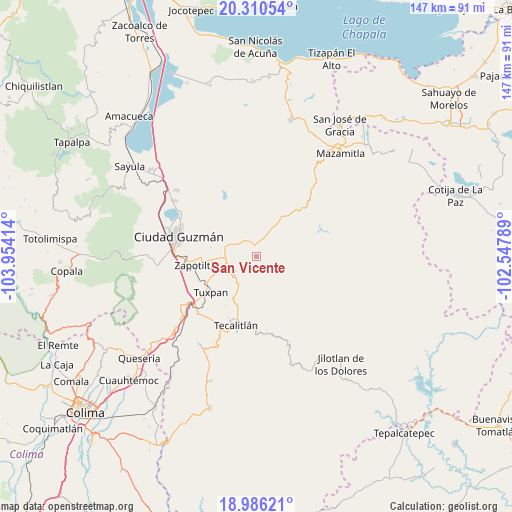
San Vicente GPS coordinates[2]
19° 38' 59.064" North, 103° 15' 3.636" West
| Map corner | latitude | longitude |
|---|---|---|
| Upper-left | 20.31054°, | -103.95414° |
| Center: | 19.64974°, | -103.25101° |
| Lower-right: | 18.98621°, | -102.54789° |
| Map W x H: | 147.3×147.3 km | = 91.5×91.5mi |
| max Lat: | 32.7° ⇑50.9% North |
| San Vicente: | 19.64974° |
| min Lat: | ⇓49.1% South 14.53588° |
| min Long | San Vicente | max Long |
| -117.105° | -103.25101° | -86.73105° |
| W 13.1%⇐ | ⇒86.9% E |
Elevation
Elevation of San Vicente is 1153 m = 3783 ft, and this is 100.7 m = 330 ft below average elevation for this country.
| Max E: |
3497 m = 11473 ft | 56.2% |
| Avg. | 1253.7 m = 4113 ft | |
| San Vicente | 1153 m = 3783 ft | |
Min E: |
-1 m = -3 ft | 43.8% |
See also: Mexico elevation on elevation.city.
Geographical zone
San Vicente is located in North Torrid zone (between Equator and Tropic of Cancer). Distance of this Northern Tropic circle is 421.1 km =261.7 mi to North.| Distance of | km | miles | from San Vicente |
|---|---|---|---|
| North Pole | 7822.2 | 4860.5 | to North |
| Arctic Circle | 5216.3 | 3241.3 | to North |
| Tropic Cancer | 421.1 | 261.7 | to North |
| Equator | 2184.8 | 1357.6 | to South |


Nearby cities:
15 places around San Vicente: (largest is in red/bold)
• Acueducto [Fraccionamiento]
20.2 km =12.6 mi,  200°
200°
• Callejones
2.4 km =1.5 mi,  329°
329°
• El Coahuayote (El Arco)
11.8 km =7.3 mi,  248°
248°
• El Rincón
16 km =9.9 mi,  277°
277°
• La Garita
19.4 km =12.1 mi,  44°
44°
• La Purísima
19.4 km =12.1 mi,  205°
205°
• Paso de Ganado
9 km =5.6 mi,  28°
28°
• San Francisco
9.7 km =6 mi, 38°
• Soyatlán de Afuera
5.7 km =3.5 mi,  323°
323°
• Tamazula de Gordiano
3.4 km =2.1 mi,  359°
359°
• Tasinaxtla (La Cañada)
9.2 km =5.7 mi, 213°
• Tecalitlán
20.6 km =12.8 mi, 196°
• Tuxpan
16.8 km =10.4 mi,  231°
231°
• Vista Hermosa
10.5 km =6.5 mi,  297°
297°
• Zapotiltic
17.6 km =10.9 mi,  261°
261°
Sources, notices
• [Note1] Compared only with cities in Mexico existing in our database
• [Src1] Map data: © OpenStreetMap contributors (CC-BY-SA)
• [Src2] Other city data from geonames.org with taken over terms of usage.
• [Src3] Geographical zone / Annual Mean Temperature by Robert A. Rohde @ Wikipedia
