El Coahuayote (El Arco) geodata
El Coahuayote (El Arco) (Jalisco) is a populated place; located in Mexico in America/Mexico_City (GMT-6) time zone. With population of 662 people, there are 13120 cities with bigger population in this country. Compared to other cities in Mexico, 51.7% of cities are located further ↑North; 87.5% of cities are located further →East and 56.1% of cities have higher elevation than El Coahuayote (El Arco). Note1
Current local time in El Coahuayote (El Arco):
01:00 AM, WednesdayDifference from your time zone: hours


El Coahuayote (El Arco) GPS coordinates[2]
19° 36' 37.008" North, 103° 21' 21.996" West
| Map corner | latitude | longitude |
|---|---|---|
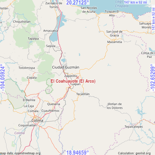
| Upper-left | 20.27125°, | -104.05924° |
| Center: | 19.61028°, | -103.35611° |
| Lower-right: | 18.94659°, | -102.65299° |
| Map W x H: | 147.3×147.3 km | = 91.5×91.5mi |
| max Lat: | 32.7° ⇑51.7% North |
| El Coahuayote (El Arco): | 19.61028° |
| min Lat: | ⇓48.3% South 14.53588° |
| min Long | El Coahuayote ( | max Long |
| -117.105° | -103.35611° | -86.73105° |
| W 12.5%⇐ | ⇒87.5% E |
Elevation
Elevation of El Coahuayote (El Arco) is 1155 m = 3789 ft, and this is 98.7 m = 324 ft below average elevation for this country.
| Max E: |
3497 m = 11473 ft | 56.1% |
| Avg. | 1253.7 m = 4113 ft | |
| El Coahuayote (El Arco) | 1155 m = 3789 ft | |
Min E: |
-1 m = -3 ft | 43.9% |
See also: Mexico elevation on elevation.city.
Geographical zone
El Coahuayote (El Arco) is located in North Torrid zone (between Equator and Tropic of Cancer). Distance of this Northern Tropic circle is 425.5 km =264.4 mi to North.| Distance of | km | miles | from El Coahuayote (El Arco) |
|---|---|---|---|
| North Pole | 7826.6 | 4863.2 | to North |
| Arctic Circle | 5220.7 | 3244 | to North |
| Tropic Cancer | 425.5 | 264.4 | to North |
| Equator | 2180.5 | 1354.9 | to South |


Nearby cities:
15 places around El Coahuayote (El Arco): (largest is in red/bold)
• Acueducto [Fraccionamiento]
15.1 km =9.4 mi,  164°
164°
• Atenquique
12.7 km =7.9 mi,  225°
225°
• Callejones
11.7 km =7.3 mi,  56°
56°
• Ciudad Guzmán
15.2 km =9.4 mi,  313°
313°
• Ciudad Guzmán [CERESO]
15.8 km =9.8 mi,  287°
287°
• El Rincón
8 km =5 mi,  322°
322°
• La Purísima
13.4 km =8.3 mi,  167°
167°
• San Juan Espanatica
13.4 km =8.3 mi,  201°
201°
• San Vicente
11.8 km =7.3 mi,  68°
68°
• Soyatlán de Afuera
11.8 km =7.3 mi,  40°
40°
• Tamazula de Gordiano
13.4 km =8.3 mi,  54°
54°
• Tasinaxtla (La Cañada)
6.8 km =4.2 mi,  119°
119°
• Tuxpan
6.4 km =4 mi, 198°
• Vista Hermosa
9.5 km =5.9 mi,  10°
10°
• Zapotiltic
6.7 km =4.2 mi, 286°
Sources, notices
• [Note1] Compared only with cities in Mexico existing in our database
• [Src1] Map data: © OpenStreetMap contributors (CC-BY-SA)
• [Src2] Other city data from geonames.org with taken over terms of usage.
• [Src3] Geographical zone / Annual Mean Temperature by Robert A. Rohde @ Wikipedia
