García geodata
García (Nuevo León) is a seat of a second-order administrative division; located in Mexico in America/Monterrey (GMT-6) time zone. With population of 93,641 people, there are 141 cities with bigger population in this country. Compared to other cities in Mexico, 94.3% of cities are located further ↓South; 70.3% of cities are located further →East and 64.4% of cities have higher elevation than García. Note1


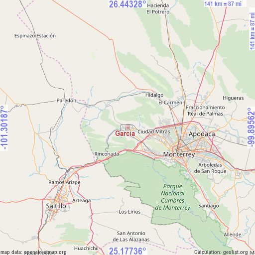
García GPS coordinates[2]
25° 48' 43.236" North, 100° 35' 55.464" West
| Map corner | latitude | longitude |
|---|---|---|
| Upper-left | 26.44328°, | -101.30187° |
| Center: | 25.81201°, | -100.59874° |
| Lower-right: | 25.17736°, | -99.89562° |
| Map W x H: | 140.8×140.8 km | = 87.5×87.5mi |
| max Lat: | 32.7° ⇑5.7% North |
| García: | 25.81201° |
| min Lat: | ⇓94.3% South 14.53588° |
| min Long | García | max Long |
| -117.105° | -100.59874° | -86.73105° |
| W 29.7%⇐ | ⇒70.3% E |
Elevation
Elevation of García is 719 m = 2359 ft, and this is 534.7 m = 1754 ft below average elevation for this country.
| Max E: |
3497 m = 11473 ft | 64.4% |
| Avg. | 1253.7 m = 4113 ft | |
| García | 719 m = 2359 ft | |
Min E: |
-1 m = -3 ft | 35.6% |
See also: García elevation on elevation.city.
Geographical zone
García is located in North temperate zone (between Tropic of Cancer and the Arctic Circle). Distance of this Northern Tropic circle is 264.1 km =164.1 mi to South.| Distance of | km | miles | from García |
|---|---|---|---|
| North Pole | 7137 | 4434.7 | to North |
| Arctic Circle | 4531.1 | 2815.5 | to North |
| Tropic Cancer | 264.1 | 164.1 | to South |
| Equator | 2870 | 1783.3 | to South |


Nearby cities:
15 places around García: (largest is in red/bold)
• Alberto Villarreal
23.8 km =14.8 mi,  51°
51°
• Alianza Real
22.1 km =13.7 mi,  78°
78°
• Hidalgo
23.2 km =14.4 mi,  39°
39°
• Las Torres de Guadalupe
2.5 km =1.6 mi,  254°
254°
• Los Parques
13.1 km =8.1 mi,  100°
100°
• Mina
22.1 km =13.7 mi,  18°
18°
• Mitras Poniente
17.8 km =11.1 mi, 103°
• Monclova Primer Sector
19.6 km =12.2 mi,  89°
89°
• Monclova Segundo Sector
20.2 km =12.6 mi, 88°
• Parque Industrial Ciudad Mitras
15.3 km =9.5 mi, 99°
• Praderas de San Francisco
19.7 km =12.2 mi, 87°
• Santa Catarina
20.9 km =13 mi,  137°
137°
• Unión Agropecuarios Lázaro Cárdenas del Norte
21.6 km =13.4 mi, 84°
• Valle de Lincoln
12.3 km =7.6 mi, 99°
• Valle de San Felipe
3.7 km =2.3 mi,  272°
272°
Sources, notices
• [Note1] Compared only with cities in Mexico existing in our database
• [Src1] Map data: © OpenStreetMap contributors (CC-BY-SA)
• [Src2] Other city data from geonames.org with taken over terms of usage.
• [Src3] Geographical zone / Annual Mean Temperature by Robert A. Rohde @ Wikipedia
