Alberto Villarreal geodata
Alberto Villarreal (Nuevo León) is a populated place; located in Mexico in America/Monterrey (GMT-6) time zone. With population of 716 people, there are 12166 cities with bigger population in this country. Compared to other cities in Mexico, 95.1% of cities are located further ↓South; 68.6% of cities are located further →East and 68.2% of cities have higher elevation than Alberto Villarreal. Note1


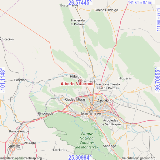
Alberto Villarreal GPS coordinates[2]
25° 56' 38.004" North, 100° 24' 42.012" West
| Map corner | latitude | longitude |
|---|---|---|
| Upper-left | 26.57445°, | -101.1148° |
| Center: | 25.94389°, | -100.41167° |
| Lower-right: | 25.30994°, | -99.70855° |
| Map W x H: | 140.6×140.6 km | = 87.4×87.4mi |
| max Lat: | 32.7° ⇑4.9% North |
| Alberto Villarreal: | 25.94389° |
| min Lat: | ⇓95.1% South 14.53588° |
| min Long | Alberto Villarr | max Long |
| -117.105° | -100.41167° | -86.73105° |
| W 31.4%⇐ | ⇒68.6% E |
Elevation
Elevation of Alberto Villarreal is 513 m = 1683 ft, and this is 740.7 m = 2430 ft below average elevation for this country.
| Max E: |
3497 m = 11473 ft | 68.2% |
| Avg. | 1253.7 m = 4113 ft | |
| Alberto Villarreal | 513 m = 1683 ft | |
Min E: |
-1 m = -3 ft | 31.8% |
See also: Mexico elevation on elevation.city.
Geographical zone
Alberto Villarreal is located in North temperate zone (between Tropic of Cancer and the Arctic Circle). Distance of this Northern Tropic circle is 278.8 km =173.2 mi to South.| Distance of | km | miles | from Alberto Villarreal |
|---|---|---|---|
| North Pole | 7122.4 | 4425.7 | to North |
| Arctic Circle | 4516.5 | 2806.4 | to North |
| Tropic Cancer | 278.8 | 173.2 | to South |
| Equator | 2884.7 | 1792.5 | to South |


Nearby cities:
15 places around Alberto Villarreal: (largest is in red/bold)
• Abasolo
1.6 km =1 mi,  81°
81°
• Alianza Real
10.7 km =6.6 mi,  164°
164°
• Buena Vista
11.4 km =7.1 mi,  153°
153°
• Carmen
4.8 km =3 mi,  99°
99°
• Emiliano Zapata
13.6 km =8.5 mi,  105°
105°
• Hidalgo
5 km =3.1 mi,  309°
309°
• Las Torres
9.4 km =5.8 mi, 84°
• Los Morales
14.5 km =9 mi,  38°
38°
• Los Villarreales
14.7 km =9.1 mi, 36°
• Mina
13.4 km =8.3 mi,  298°
298°
• Monclova Primer Sector
14.4 km =8.9 mi,  176°
176°
• Monclova Segundo Sector
14.4 km =8.9 mi,  174°
174°
• Praderas de San Francisco
14 km =8.7 mi, 176°
• Salinas Victoria
12.3 km =7.6 mi, 79°
• Unión Agropecuarios Lázaro Cárdenas del Norte
12.7 km =7.9 mi, 167°
Sources, notices
• [Note1] Compared only with cities in Mexico existing in our database
• [Src1] Map data: © OpenStreetMap contributors (CC-BY-SA)
• [Src2] Other city data from geonames.org with taken over terms of usage.
• [Src3] Geographical zone / Annual Mean Temperature by Robert A. Rohde @ Wikipedia
