Hidalgo geodata
Hidalgo (Nuevo León) is a seat of a second-order administrative division; located in Mexico in America/Monterrey (GMT-6) time zone. With population of 16,524 people, there are 581 cities with bigger population in this country. Compared to other cities in Mexico, 95.2% of cities are located further ↓South; 69% of cities are located further →East and 67.6% of cities have higher elevation than Hidalgo. Note1


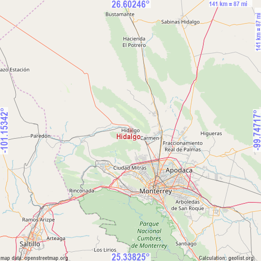
Hidalgo GPS coordinates[2]
25° 58' 19.38" North, 100° 27' 1.044" West
| Map corner | latitude | longitude |
|---|---|---|
| Upper-left | 26.60246°, | -101.15342° |
| Center: | 25.97205°, | -100.45029° |
| Lower-right: | 25.33825°, | -99.74717° |
| Map W x H: | 140.6×140.6 km | = 87.4×87.4mi |
| max Lat: | 32.7° ⇑4.8% North |
| Hidalgo: | 25.97205° |
| min Lat: | ⇓95.2% South 14.53588° |
| min Long | Hidalgo | max Long |
| -117.105° | -100.45029° | -86.73105° |
| W 31%⇐ | ⇒69% E |
Elevation
Elevation of Hidalgo is 550 m = 1804 ft, and this is 703.7 m = 2309 ft below average elevation for this country.
| Max E: |
3497 m = 11473 ft | 67.6% |
| Avg. | 1253.7 m = 4113 ft | |
| Hidalgo | 550 m = 1804 ft | |
Min E: |
-1 m = -3 ft | 32.4% |
See also: Mexico elevation on elevation.city.
Geographical zone
Hidalgo is located in North temperate zone (between Tropic of Cancer and the Arctic Circle). Distance of this Northern Tropic circle is 281.9 km =175.2 mi to South.| Distance of | km | miles | from Hidalgo |
|---|---|---|---|
| North Pole | 7119.2 | 4423.7 | to North |
| Arctic Circle | 4513.4 | 2804.5 | to North |
| Tropic Cancer | 281.9 | 175.2 | to South |
| Equator | 2887.8 | 1794.4 | to South |


Nearby cities:
15 places around Hidalgo: (largest is in red/bold)
• Abasolo
6.2 km =3.9 mi,  118°
118°
• Alberto Villarreal
5 km =3.1 mi,  129°
129°
• Alianza Real
15 km =9.3 mi,  153°
153°
• Buena Vista
16.1 km =10 mi, 145°
• Carmen
9.5 km =5.9 mi,  114°
114°
• Emiliano Zapata
18.3 km =11.4 mi, 112°
• Las Torres
13.4 km =8.3 mi,  99°
99°
• Los Morales
15.3 km =9.5 mi,  57°
57°
• Los Villarreales
15.3 km =9.5 mi, 55°
• Mina
8.6 km =5.3 mi,  292°
292°
• Monclova Primer Sector
18.1 km =11.2 mi,  164°
164°
• Monclova Segundo Sector
18.2 km =11.3 mi, 162°
• Praderas de San Francisco
17.7 km =11 mi, 164°
• Salinas Victoria
16 km =9.9 mi,  93°
93°
• Unión Agropecuarios Lázaro Cárdenas del Norte
16.9 km =10.5 mi, 156°
Sources, notices
• [Note1] Compared only with cities in Mexico existing in our database
• [Src1] Map data: © OpenStreetMap contributors (CC-BY-SA)
• [Src2] Other city data from geonames.org with taken over terms of usage.
• [Src3] Geographical zone / Annual Mean Temperature by Robert A. Rohde @ Wikipedia
