Velardeña geodata
Velardeña (Durango) is a populated place; located in Mexico in America/Monterrey (GMT-6) time zone. With population of 2,425 people, there are 3634 cities with bigger population in this country. Compared to other cities in Mexico, 91.9% of cities are located further ↓South; 89.2% of cities are located further →East and 51.2% of cities have higher elevation than Velardeña. Note1


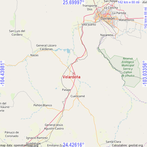
Velardeña GPS coordinates[2]
25° 3' 52.992" North, 103° 44' 12.048" West
| Map corner | latitude | longitude |
|---|---|---|
| Upper-left | 25.69997°, | -104.43981° |
| Center: | 25.06472°, | -103.73668° |
| Lower-right: | 24.42616°, | -103.03356° |
| Map W x H: | 141.6×141.6 km | = 88×88mi |
| max Lat: | 32.7° ⇑8.1% North |
| Velardeña: | 25.06472° |
| min Lat: | ⇓91.9% South 14.53588° |
| min Long | Velardeña | max Long |
| -117.105° | -103.73668° | -86.73105° |
| W 10.8%⇐ | ⇒89.2% E |
Elevation
Elevation of Velardeña is 1375 m = 4511 ft, and this is 121.3 m = 398 ft above average elevation for this country.
| Max E: |
3497 m = 11473 ft | 51.2% |
| Velardeña | 1375 m 4511 ft | |
| Avg. | 1253.7 m = 4113 ft | |
Min E: |
-1 m = -3 ft | 48.8% |
See also: Mexico elevation on elevation.city.
Geographical zone
Velardeña is located in North temperate zone (between Tropic of Cancer and the Arctic Circle). Distance of this Northern Tropic circle is 181 km =112.5 mi to South.| Distance of | km | miles | from Velardeña |
|---|---|---|---|
| North Pole | 7220.1 | 4486.4 | to North |
| Arctic Circle | 4614.2 | 2867.1 | to North |
| Tropic Cancer | 181 | 112.5 | to South |
| Equator | 2786.9 | 1731.7 | to South |


Nearby cities:
15 places around Velardeña: (largest is in red/bold)
• Cuencamé de Ceniceros
21.9 km =13.6 mi,  169°
169°
• Emilio Carranza
30.1 km =18.7 mi,  315°
315°
• General Lázaro Cárdenas
36.6 km =22.7 mi,  314°
314°
• Ignacio Zaragoza
36.4 km =22.6 mi,  77°
77°
• Jalisco
34.1 km =21.2 mi,  60°
60°
• Las Mercedes
11.5 km =7.1 mi,  255°
255°
• Los Cuatillos
4.8 km =3 mi, 314°
• Nuevo Graseros
21.6 km =13.4 mi,  358°
358°
• Pasaje
16.8 km =10.4 mi,  205°
205°
• Paso Nacional
36 km =22.4 mi, 307°
• Pedriceña
8 km =5 mi, 318°
• Pueblo de Santiago
22.7 km =14.1 mi, 166°
• San José de Zaragoza
32.7 km =20.3 mi, 56°
• Santa Teresa de la Uña
33.2 km =20.6 mi, 311°
• Yerbanís
37.9 km =23.5 mi,  196°
196°
Sources, notices
• [Note1] Compared only with cities in Mexico existing in our database
• [Src1] Map data: © OpenStreetMap contributors (CC-BY-SA)
• [Src2] Other city data from geonames.org with taken over terms of usage.
• [Src3] Geographical zone / Annual Mean Temperature by Robert A. Rohde @ Wikipedia
