Pasaje geodata
Pasaje (Durango) is a populated place; located in Mexico in America/Monterrey (GMT-6) time zone. With population of 1,474 people, there are 5858 cities with bigger population in this country. Compared to other cities in Mexico, 91.7% of cities are located further ↓South; 89.4% of cities are located further →East and 54.9% of cities have lower elevation than Pasaje. Note1


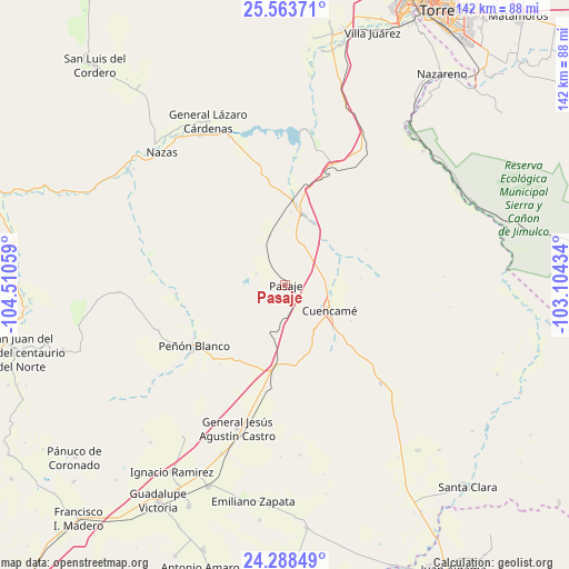
Pasaje GPS coordinates[2]
24° 55' 39.9" North, 103° 48' 26.856" West
| Map corner | latitude | longitude |
|---|---|---|
| Upper-left | 25.56371°, | -104.51059° |
| Center: | 24.92775°, | -103.80746° |
| Lower-right: | 24.28849°, | -103.10434° |
| Map W x H: | 141.8×141.8 km | = 88.1×88.1mi |
| max Lat: | 32.7° ⇑8.3% North |
| Pasaje: | 24.92775° |
| min Lat: | ⇓91.7% South 14.53588° |
| min Long | Pasaje | max Long |
| -117.105° | -103.80746° | -86.73105° |
| W 10.6%⇐ | ⇒89.4% E |
Elevation
Elevation of Pasaje is 1586 m = 5203 ft, and this is 332.3 m = 1090 ft above average elevation for this country.
| Max E: |
3497 m = 11473 ft | 45.1% |
| Pasaje | 1586 m 5203 ft | |
| Avg. | 1253.7 m = 4113 ft | |
Min E: |
-1 m = -3 ft | 54.9% |
See also: Mexico elevation on elevation.city.
Geographical zone
Pasaje is located in North temperate zone (between Tropic of Cancer and the Arctic Circle). Distance of this Northern Tropic circle is 165.8 km =103 mi to South.| Distance of | km | miles | from Pasaje |
|---|---|---|---|
| North Pole | 7235.4 | 4495.9 | to North |
| Arctic Circle | 4629.5 | 2876.6 | to North |
| Tropic Cancer | 165.8 | 103 | to South |
| Equator | 2771.7 | 1722.3 | to South |


Nearby cities:
15 places around Pasaje: (largest is in red/bold)
• 12 de Diciembre (Sombreretillo)
33.9 km =21.1 mi,  135°
135°
• Cuencamé de Ceniceros
12.8 km =8 mi,  119°
119°
• Emilio Carranza
39.3 km =24.4 mi,  339°
339°
• General Lázaro Cárdenas
45 km =28 mi,  334°
334°
• Las Mercedes
12.9 km =8 mi, 341°
• Los Cuatillos
19 km =11.8 mi,  11°
11°
• Luis Moya
44.9 km =27.9 mi,  200°
200°
• Nuevo Graseros
37.4 km =23.2 mi, 9°
• Paso Nacional
43 km =26.7 mi, 330°
• Pedriceña
21.3 km =13.2 mi,  4°
4°
• Peñón Blanco
26.7 km =16.6 mi,  235°
235°
• Pueblo de Santiago
14.1 km =8.8 mi, 118°
• Santa Teresa de la Uña
41.2 km =25.6 mi, 334°
• Velardeña
16.8 km =10.4 mi,  25°
25°
• Yerbanís
21.4 km =13.3 mi,  189°
189°
Sources, notices
• [Note1] Compared only with cities in Mexico existing in our database
• [Src1] Map data: © OpenStreetMap contributors (CC-BY-SA)
• [Src2] Other city data from geonames.org with taken over terms of usage.
• [Src3] Geographical zone / Annual Mean Temperature by Robert A. Rohde @ Wikipedia
