Pedriceña geodata
Pedriceña (Durango) is a populated place; located in Mexico in America/Monterrey (GMT-6) time zone. With population of 1,765 people, there are 4919 cities with bigger population in this country. Compared to other cities in Mexico, 92% of cities are located further ↓South; 89.4% of cities are located further →East and 52.6% of cities have higher elevation than Pedriceña. Note1


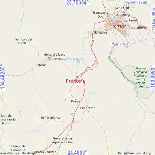
Pedriceña GPS coordinates[2]
25° 7' 6.888" North, 103° 47' 21.912" West
| Map corner | latitude | longitude |
|---|---|---|
| Upper-left | 25.75354°, | -104.49255° |
| Center: | 25.11858°, | -103.78942° |
| Lower-right: | 24.4803°, | -103.0863° |
| Map W x H: | 141.6×141.6 km | = 88×88mi |
| max Lat: | 32.7° ⇑8% North |
| Pedriceña: | 25.11858° |
| min Lat: | ⇓92% South 14.53588° |
| min Long | Pedriceña | max Long |
| -117.105° | -103.78942° | -86.73105° |
| W 10.6%⇐ | ⇒89.4% E |
Elevation
Elevation of Pedriceña is 1309 m = 4295 ft, and this is 55.3 m = 181 ft above average elevation for this country.
| Max E: |
3497 m = 11473 ft | 52.6% |
| Pedriceña | 1309 m 4295 ft | |
| Avg. | 1253.7 m = 4113 ft | |
Min E: |
-1 m = -3 ft | 47.4% |
See also: Mexico elevation on elevation.city.
Geographical zone
Pedriceña is located in North temperate zone (between Tropic of Cancer and the Arctic Circle). Distance of this Northern Tropic circle is 187 km =116.2 mi to South.| Distance of | km | miles | from Pedriceña |
|---|---|---|---|
| North Pole | 7214.1 | 4482.6 | to North |
| Arctic Circle | 4608.2 | 2863.4 | to North |
| Tropic Cancer | 187 | 116.2 | to South |
| Equator | 2792.9 | 1735.4 | to South |


Nearby cities:
15 places around Pedriceña: (largest is in red/bold)
• Cuencamé de Ceniceros
29 km =18 mi,  161°
161°
• Emilio Carranza
22.1 km =13.7 mi,  314°
314°
• General Lázaro Cárdenas
28.6 km =17.8 mi, 312°
• Jalisco
36.7 km =22.8 mi,  72°
72°
• La Perla
32 km =19.9 mi, 305°
• Las Mercedes
10.7 km =6.6 mi,  213°
213°
• Los Cuatillos
3.2 km =2 mi,  144°
144°
• Nazas
34.8 km =21.6 mi,  289°
289°
• Nuevo Graseros
16.3 km =10.1 mi,  16°
16°
• Pasaje
21.3 km =13.2 mi,  184°
184°
• Paso Nacional
28.2 km =17.5 mi,  304°
304°
• Pueblo de Santiago
29.9 km =18.6 mi, 159°
• San José de Zaragoza
34.7 km =21.6 mi, 69°
• Santa Teresa de la Uña
25.3 km =15.7 mi, 309°
• Velardeña
8 km =5 mi, 138°
Sources, notices
• [Note1] Compared only with cities in Mexico existing in our database
• [Src1] Map data: © OpenStreetMap contributors (CC-BY-SA)
• [Src2] Other city data from geonames.org with taken over terms of usage.
• [Src3] Geographical zone / Annual Mean Temperature by Robert A. Rohde @ Wikipedia
