Ursulo Galván geodata
Ursulo Galván (Nayarit) is a populated place; located in Mexico in America/Mazatlan (GMT-7) time zone. With population of 629 people, there are 13762 cities with bigger population in this country. Compared to other cities in Mexico, 75.8% of cities are located further ↓South; 92.9% of cities are located further →East and 95.7% of cities have higher elevation than Ursulo Galván. Note1


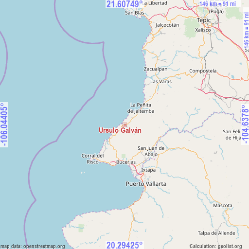
Ursulo Galván GPS coordinates[2]
20° 57' 8.316" North, 105° 20' 27.312" West
| Map corner | latitude | longitude |
|---|---|---|
| Upper-left | 21.60749°, | -106.04405° |
| Center: | 20.95231°, | -105.34092° |
| Lower-right: | 20.29425°, | -104.6378° |
| Map W x H: | 146×146 km | = 90.7×90.7mi |
| max Lat: | 32.7° ⇑24.2% North |
| Ursulo Galván: | 20.95231° |
| min Lat: | ⇓75.8% South 14.53588° |
| min Long | Ursulo Galván | max Long |
| -117.105° | -105.34092° | -86.73105° |
| W 7.1%⇐ | ⇒92.9% E |
Elevation
Elevation of Ursulo Galván is 12 m = 39 ft, and this is 1241.7 m = 4074 ft below average elevation for this country.
| Max E: |
3497 m = 11473 ft | 95.7% |
| Avg. | 1253.7 m = 4113 ft | |
| Ursulo Galván | 12 m = 39 ft | |
Min E: |
-1 m = -3 ft | 4.3% |
See also: Mexico elevation on elevation.city.
Geographical zone
Ursulo Galván is located in North Torrid zone (between Equator and Tropic of Cancer). Distance of this Northern Tropic circle is 276.2 km =171.6 mi to North.| Distance of | km | miles | from Ursulo Galván |
|---|---|---|---|
| North Pole | 7677.4 | 4770.5 | to North |
| Arctic Circle | 5071.5 | 3151.3 | to North |
| Tropic Cancer | 276.2 | 171.6 | to North |
| Equator | 2329.7 | 1447.6 | to South |


Nearby cities:
15 places around Ursulo Galván: (largest is in red/bold)
• Bucerías
21.8 km =13.5 mi,  178°
178°
• Colonia Paraíso Escondido
15.5 km =9.6 mi,  43°
43°
• Cruz de Huanacaxtle
22.4 km =13.9 mi,  189°
189°
• El Colomo
21.3 km =13.2 mi,  115°
115°
• Higuera Blanca
21.7 km =13.5 mi,  217°
217°
• La Peñita de Jaltomba
13.6 km =8.5 mi,  45°
45°
• Lima de Abajo
22.3 km =13.9 mi, 41°
• Lo de Marcos
1.2 km =0.7 mi,  284°
284°
• Monteón
6.1 km =3.8 mi, 44°
• Rincón de Guayabitos
10.7 km =6.6 mi, 42°
• San Francisco
9.3 km =5.8 mi,  233°
233°
• San Ignacio
14.4 km =8.9 mi, 215°
• San Juan de Abajo
21.8 km =13.5 mi,  134°
134°
• Sayulita
13.8 km =8.6 mi, 228°
• Valle de Banderas
18.7 km =11.6 mi,  149°
149°
Sources, notices
• [Note1] Compared only with cities in Mexico existing in our database
• [Src1] Map data: © OpenStreetMap contributors (CC-BY-SA)
• [Src2] Other city data from geonames.org with taken over terms of usage.
• [Src3] Geographical zone / Annual Mean Temperature by Robert A. Rohde @ Wikipedia
