Tuxcacuesco geodata
Tuxcacuesco (Jalisco) is a seat of a second-order administrative division; located in Mexico in America/Mexico_City (GMT-6) time zone. With population of 1,538 people, there are 5618 cities with bigger population in this country. Compared to other cities in Mexico, 50.4% of cities are located further ↓South; 89.9% of cities are located further →East and 64.4% of cities have higher elevation than Tuxcacuesco. Note1


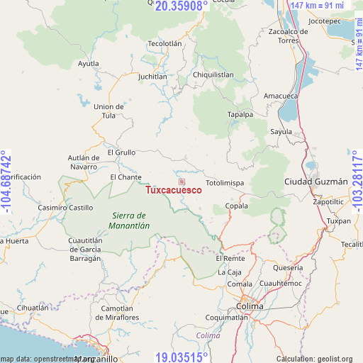
Tuxcacuesco GPS coordinates[2]
19° 41' 54.528" North, 103° 59' 3.444" West
| Map corner | latitude | longitude |
|---|---|---|
| Upper-left | 20.35908°, | -104.68742° |
| Center: | 19.69848°, | -103.98429° |
| Lower-right: | 19.03515°, | -103.28117° |
| Map W x H: | 147.2×147.2 km | = 91.5×91.5mi |
| max Lat: | 32.7° ⇑49.6% North |
| Tuxcacuesco: | 19.69848° |
| min Lat: | ⇓50.4% South 14.53588° |
| min Long | Tuxcacuesco | max Long |
| -117.105° | -103.98429° | -86.73105° |
| W 10.1%⇐ | ⇒89.9% E |
Elevation
Elevation of Tuxcacuesco is 727 m = 2385 ft, and this is 526.7 m = 1728 ft below average elevation for this country.
| Max E: |
3497 m = 11473 ft | 64.4% |
| Avg. | 1253.7 m = 4113 ft | |
| Tuxcacuesco | 727 m = 2385 ft | |
Min E: |
-1 m = -3 ft | 35.6% |
See also: Mexico elevation on elevation.city.
Geographical zone
Tuxcacuesco is located in North Torrid zone (between Equator and Tropic of Cancer). Distance of this Northern Tropic circle is 415.7 km =258.3 mi to North.| Distance of | km | miles | from Tuxcacuesco |
|---|---|---|---|
| North Pole | 7816.8 | 4857.1 | to North |
| Arctic Circle | 5210.9 | 3237.9 | to North |
| Tropic Cancer | 415.7 | 258.3 | to North |
| Equator | 2190.3 | 1361 | to South |


Nearby cities:
15 places around Tuxcacuesco: (largest is in red/bold)
• Alista
21.6 km =13.4 mi,  109°
109°
• Coatlancillo
21.8 km =13.5 mi,  5°
5°
• El Chante
22.7 km =14.1 mi,  275°
275°
• El Limón
22.9 km =14.2 mi,  308°
308°
• El Paso Real
10.8 km =6.7 mi,  166°
166°
• Jiquilpan
23.3 km =14.5 mi,  67°
67°
• La Ciénega
22.3 km =13.9 mi, 313°
• Las Primaveras [Invernadero]
15.8 km =9.8 mi,  91°
91°
• San Antonio
14.9 km =9.3 mi,  42°
42°
• San Gabriel
7.8 km =4.8 mi,  347°
347°
• San José del Rincón
15.2 km =9.4 mi,  60°
60°
• San Pedro Toxín
12.2 km =7.6 mi, 171°
• Teutlán
15.5 km =9.6 mi,  151°
151°
• Tolimán
13 km =8.1 mi, 146°
• Tonaya
9.9 km =6.2 mi, 7°
Sources, notices
• [Note1] Compared only with cities in Mexico existing in our database
• [Src1] Map data: © OpenStreetMap contributors (CC-BY-SA)
• [Src2] Other city data from geonames.org with taken over terms of usage.
• [Src3] Geographical zone / Annual Mean Temperature by Robert A. Rohde @ Wikipedia
