Jiquilpan geodata
Jiquilpan (Jalisco) is a populated place; located in Mexico in America/Mexico_City (GMT-6) time zone. With population of 1,789 people, there are 4860 cities with bigger population in this country. Compared to other cities in Mexico, 52.2% of cities are located further ↓South; 89.3% of cities are located further →East and 52.8% of cities have higher elevation than Jiquilpan. Note1


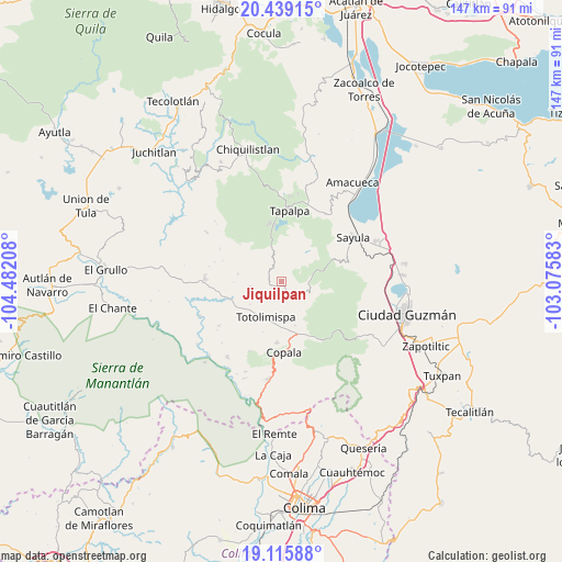
Jiquilpan GPS coordinates[2]
19° 46' 44.004" North, 103° 46' 44.22" West
| Map corner | latitude | longitude |
|---|---|---|
| Upper-left | 20.43915°, | -104.48208° |
| Center: | 19.77889°, | -103.77895° |
| Lower-right: | 19.11588°, | -103.07583° |
| Map W x H: | 147.1×147.1 km | = 91.4×91.4mi |
| max Lat: | 32.7° ⇑47.8% North |
| Jiquilpan: | 19.77889° |
| min Lat: | ⇓52.2% South 14.53588° |
| min Long | Jiquilpan | max Long |
| -117.105° | -103.77895° | -86.73105° |
| W 10.7%⇐ | ⇒89.3% E |
Elevation
Elevation of Jiquilpan is 1301 m = 4268 ft, and this is 47.3 m = 155 ft above average elevation for this country.
| Max E: |
3497 m = 11473 ft | 52.8% |
| Jiquilpan | 1301 m 4268 ft | |
| Avg. | 1253.7 m = 4113 ft | |
Min E: |
-1 m = -3 ft | 47.2% |
See also: Mexico elevation on elevation.city.
Geographical zone
Jiquilpan is located in North Torrid zone (between Equator and Tropic of Cancer). Distance of this Northern Tropic circle is 406.7 km =252.7 mi to North.| Distance of | km | miles | from Jiquilpan |
|---|---|---|---|
| North Pole | 7807.9 | 4851.6 | to North |
| Arctic Circle | 5202 | 3232.4 | to North |
| Tropic Cancer | 406.7 | 252.7 | to North |
| Equator | 2199.2 | 1366.5 | to South |


Nearby cities:
15 places around Jiquilpan: (largest is in red/bold)
• Alista
16.1 km =10 mi,  183°
183°
• Apango
7.1 km =4.4 mi,  88°
88°
• Atacco
16.9 km =10.5 mi,  13°
13°
• Copala
18.7 km =11.6 mi, 177°
• El Jazmín
15.7 km =9.8 mi,  152°
152°
• Las Primaveras [Invernadero]
11 km =6.8 mi,  211°
211°
• Los Colonos
18.3 km =11.4 mi,  1°
1°
• San Antonio
11.5 km =7.1 mi,  279°
279°
• San Antonio
22.2 km =13.8 mi,  19°
19°
• San Gabriel
3.6 km =2.2 mi,  160°
160°
• San Gabriel
23.2 km =14.4 mi,  266°
266°
• San José del Rincón
8.4 km =5.2 mi,  260°
260°
• Sayula
21.9 km =13.6 mi,  58°
58°
• Tapalpa
18.7 km =11.6 mi, 6°
• Tonaya
20.1 km =12.5 mi, 272°
Sources, notices
• [Note1] Compared only with cities in Mexico existing in our database
• [Src1] Map data: © OpenStreetMap contributors (CC-BY-SA)
• [Src2] Other city data from geonames.org with taken over terms of usage.
• [Src3] Geographical zone / Annual Mean Temperature by Robert A. Rohde @ Wikipedia
