Torreón geodata
Torreón (Coahuila) is a seat of a second-order administrative division; located in Mexico in America/Monterrey (GMT-6) time zone. With population of 608,836 people, there are 29 cities with bigger population in this country. Compared to other cities in Mexico, 92.9% of cities are located further ↓South; 87.9% of cities are located further →East and 56.9% of cities have higher elevation than Torreón. Note1


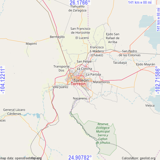
Torreón GPS coordinates[2]
25° 32' 38.004" North, 103° 25' 8.328" West
| Map corner | latitude | longitude |
|---|---|---|
| Upper-left | 26.1766°, | -104.12211° |
| Center: | 25.54389°, | -103.41898° |
| Lower-right: | 24.90782°, | -102.71586° |
| Map W x H: | 141.1×141.1 km | = 87.7×87.7mi |
| max Lat: | 32.7° ⇑7.1% North |
| Torreón: | 25.54389° |
| min Lat: | ⇓92.9% South 14.53588° |
| min Long | Torreón | max Long |
| -117.105° | -103.41898° | -86.73105° |
| W 12.1%⇐ | ⇒87.9% E |
Elevation
Elevation of Torreón is 1124 m = 3688 ft, and this is 129.7 m = 426 ft below average elevation for this country.
| Max E: |
3497 m = 11473 ft | 56.9% |
| Avg. | 1253.7 m = 4113 ft | |
| Torreón | 1124 m = 3688 ft | |
Min E: |
-1 m = -3 ft | 43.1% |
See also: Torreón elevation on elevation.city.
Geographical zone
Torreón is located in North temperate zone (between Tropic of Cancer and the Arctic Circle). Distance of this Northern Tropic circle is 234.3 km =145.6 mi to South.| Distance of | km | miles | from Torreón |
|---|---|---|---|
| North Pole | 7166.8 | 4453.2 | to North |
| Arctic Circle | 4561 | 2834.1 | to North |
| Tropic Cancer | 234.3 | 145.6 | to South |
| Equator | 2840.2 | 1764.8 | to South |


Nearby cities:
15 places around Torreón: (largest is in red/bold)
• Ciudad Lerdo
10.6 km =6.6 mi,  265°
265°
• El Cariño
10.1 km =6.3 mi,  346°
346°
• El Huarache (El Guarache)
7.3 km =4.5 mi,  248°
248°
• El Perú
10 km =6.2 mi,  48°
48°
• Fraccionamiento la Noria
7.7 km =4.8 mi,  78°
78°
• Gómez Palacio
8.2 km =5.1 mi,  290°
290°
• La Concha
10.8 km =6.7 mi,  20°
20°
• La Paz
8.2 km =5.1 mi, 47°
• La Perla
8.6 km =5.3 mi,  127°
127°
• Nazas (Las Lagartijas)
10.4 km =6.5 mi,  337°
337°
• Paso del Aguila
9.9 km =6.2 mi,  28°
28°
• Rancho Alegre
10.2 km =6.3 mi,  116°
116°
• Santa Fé
9.1 km =5.7 mi,  73°
73°
• Villa de Guadalupe
7.8 km =4.8 mi, 245°
• Álvaro Obregón
9.2 km =5.7 mi, 249°
Sources, notices
• [Note1] Compared only with cities in Mexico existing in our database
• [Src1] Map data: © OpenStreetMap contributors (CC-BY-SA)
• [Src2] Other city data from geonames.org with taken over terms of usage.
• [Src3] Geographical zone / Annual Mean Temperature by Robert A. Rohde @ Wikipedia
