La Perla geodata
La Perla (Coahuila) is a populated place; located in Mexico in America/Monterrey (GMT-6) time zone. With population of 1,591 people, there are 5429 cities with bigger population in this country. Compared to other cities in Mexico, 92.7% of cities are located further ↓South; 87.4% of cities are located further →East and 56.9% of cities have higher elevation than La Perla. Note1


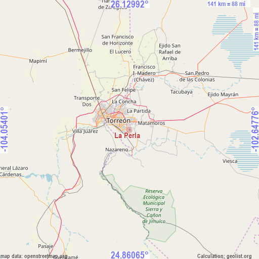
La Perla GPS coordinates[2]
25° 29' 49.056" North, 103° 21' 3.168" West
| Map corner | latitude | longitude |
|---|---|---|
| Upper-left | 26.12992°, | -104.05401° |
| Center: | 25.49696°, | -103.35088° |
| Lower-right: | 24.86065°, | -102.64776° |
| Map W x H: | 141.1×141.1 km | = 87.7×87.7mi |
| max Lat: | 32.7° ⇑7.3% North |
| La Perla: | 25.49696° |
| min Lat: | ⇓92.7% South 14.53588° |
| min Long | La Perla | max Long |
| -117.105° | -103.35088° | -86.73105° |
| W 12.6%⇐ | ⇒87.4% E |
Elevation
Elevation of La Perla is 1124 m = 3688 ft, and this is 129.7 m = 426 ft below average elevation for this country.
| Max E: |
3497 m = 11473 ft | 56.9% |
| Avg. | 1253.7 m = 4113 ft | |
| La Perla | 1124 m = 3688 ft | |
Min E: |
-1 m = -3 ft | 43.1% |
See also: Mexico elevation on elevation.city.
Geographical zone
La Perla is located in North temperate zone (between Tropic of Cancer and the Arctic Circle). Distance of this Northern Tropic circle is 229.1 km =142.4 mi to South.| Distance of | km | miles | from La Perla |
|---|---|---|---|
| North Pole | 7172.1 | 4456.5 | to North |
| Arctic Circle | 4566.2 | 2837.3 | to North |
| Tropic Cancer | 229.1 | 142.4 | to South |
| Equator | 2835 | 1761.6 | to South |


Nearby cities:
15 places around La Perla: (largest is in red/bold)
• El Consuelo
11.2 km =7 mi,  42°
42°
• El Perú
11.8 km =7.3 mi,  3°
3°
• Fraccionamiento la Noria
6.7 km =4.2 mi,  6°
6°
• La Corona
13.3 km =8.3 mi, 43°
• La Esperanza
10.4 km =6.5 mi, 42°
• La Palma
12.7 km =7.9 mi, 13°
• La Partida
11.7 km =7.3 mi,  25°
25°
• La Paz
10.8 km =6.7 mi,  355°
355°
• Matamoros
12.7 km =7.9 mi,  74°
74°
• Nazareno
12.9 km =8 mi,  212°
212°
• Nuevo Mieleras
6.4 km =4 mi,  166°
166°
• Rancho Alegre
2.4 km =1.5 mi,  75°
75°
• Santa Fé
8 km =5 mi, 13°
• Santo Niño Aguanaval
10.3 km =6.4 mi,  135°
135°
• Torreón
8.6 km =5.3 mi,  307°
307°
Sources, notices
• [Note1] Compared only with cities in Mexico existing in our database
• [Src1] Map data: © OpenStreetMap contributors (CC-BY-SA)
• [Src2] Other city data from geonames.org with taken over terms of usage.
• [Src3] Geographical zone / Annual Mean Temperature by Robert A. Rohde @ Wikipedia
