Tlapehuala geodata
Tlapehuala (Guerrero) is a seat of a second-order administrative division; located in Mexico in America/Mexico_City (GMT-6) time zone. With population of 9,331 people, there are 1019 cities with bigger population in this country. Compared to other cities in Mexico, 75.7% of cities are located further ↑North; 69.8% of cities are located further →East and 73.2% of cities have higher elevation than Tlapehuala. Note1


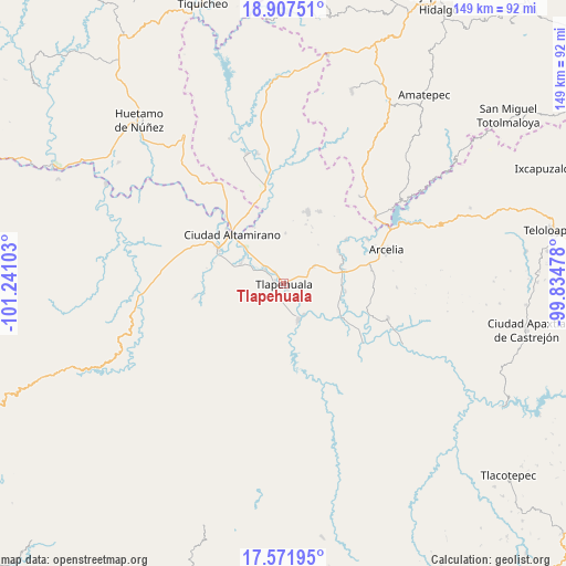
Tlapehuala GPS coordinates[2]
18° 14' 27.636" North, 100° 32' 16.44" West
| Map corner | latitude | longitude |
|---|---|---|
| Upper-left | 18.90751°, | -101.24103° |
| Center: | 18.24101°, | -100.5379° |
| Lower-right: | 17.57195°, | -99.83478° |
| Map W x H: | 148.5×148.5 km | = 92.3×92.3mi |
| max Lat: | 32.7° ⇑75.7% North |
| Tlapehuala: | 18.24101° |
| min Lat: | ⇓24.3% South 14.53588° |
| min Long | Tlapehuala | max Long |
| -117.105° | -100.5379° | -86.73105° |
| W 30.2%⇐ | ⇒69.8% E |
Elevation
Elevation of Tlapehuala is 281 m = 922 ft, and this is 972.7 m = 3191 ft below average elevation for this country.
| Max E: |
3497 m = 11473 ft | 73.2% |
| Avg. | 1253.7 m = 4113 ft | |
| Tlapehuala | 281 m = 922 ft | |
Min E: |
-1 m = -3 ft | 26.8% |
See also: Mexico elevation on elevation.city.
Geographical zone
Tlapehuala is located in North Torrid zone (between Equator and Tropic of Cancer). Distance of this Northern Tropic circle is 577.7 km =359 mi to North.| Distance of | km | miles | from Tlapehuala |
|---|---|---|---|
| North Pole | 7978.9 | 4957.9 | to North |
| Arctic Circle | 5373 | 3338.6 | to North |
| Tropic Cancer | 577.7 | 359 | to North |
| Equator | 2028.2 | 1260.3 | to South |


Nearby cities:
15 places around Tlapehuala: (largest is in red/bold)
• Ayavitle
5.8 km =3.6 mi,  140°
140°
• Cantón de Guerrero
1.2 km =0.7 mi,  200°
200°
• Changata
6.1 km =3.8 mi,  305°
305°
• Corral Falso
2.4 km =1.5 mi,  280°
280°
• Las Anonitas
5.6 km =3.5 mi,  226°
226°
• Morelita
4.3 km =2.7 mi,  319°
319°
• Nuevo Guerrero
2.1 km =1.3 mi, 142°
• Rincón del Gallo (San José Guadalupe)
4.8 km =3 mi,  40°
40°
• San Antonio de las Huertas
5 km =3.1 mi,  24°
24°
• San Jerónimo el Grande
5 km =3.1 mi,  130°
130°
• San Lorenzo
8.5 km =5.3 mi,  295°
295°
• San Mateo
5.4 km =3.4 mi,  154°
154°
• Sinahua
8 km =5 mi, 304°
• Tiringueo
3.7 km =2.3 mi,  326°
326°
• Villa Nicolás Bravo
3.2 km =2 mi, 199°
Sources, notices
• [Note1] Compared only with cities in Mexico existing in our database
• [Src1] Map data: © OpenStreetMap contributors (CC-BY-SA)
• [Src2] Other city data from geonames.org with taken over terms of usage.
• [Src3] Geographical zone / Annual Mean Temperature by Robert A. Rohde @ Wikipedia
