San Jerónimo el Grande geodata
San Jerónimo el Grande (Guerrero) is a populated place; located in Mexico in America/Mexico_City (GMT-6) time zone. With population of 1,472 people, there are 5873 cities with bigger population in this country. Compared to other cities in Mexico, 76.1% of cities are located further ↑North; 69.5% of cities are located further →East and 73.4% of cities have higher elevation than San Jerónimo el Grande. Note1
Current local time in San Jerónimo el Grande:
08:28 AM, WednesdayDifference from your time zone: hours


San Jerónimo el Grande GPS coordinates[2]
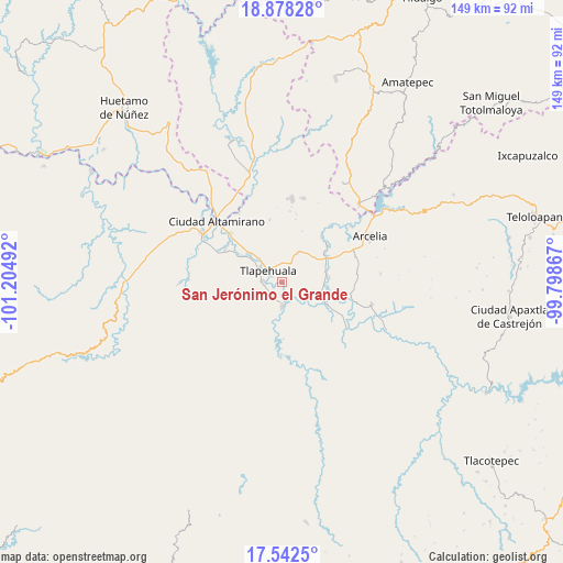
18° 12' 42.012" North, 100° 30' 6.444" West
| Map corner | latitude | longitude |
|---|---|---|
| Upper-left | 18.87828°, | -101.20492° |
| Center: | 18.21167°, | -100.50179° |
| Lower-right: | 17.5425°, | -99.79867° |
| Map W x H: | 148.5×148.5 km | = 92.3×92.3mi |
| max Lat: | 32.7° ⇑76.1% North |
| San Jerónimo el Grande: | 18.21167° |
| min Lat: | ⇓23.9% South 14.53588° |
| min Long | San Jerónimo e | max Long |
| -117.105° | -100.50179° | -86.73105° |
| W 30.5%⇐ | ⇒69.5% E |
Elevation
Elevation of San Jerónimo el Grande is 276 m = 906 ft, and this is 977.7 m = 3208 ft below average elevation for this country.
| Max E: |
3497 m = 11473 ft | 73.4% |
| Avg. | 1253.7 m = 4113 ft | |
| San Jerónimo el Grande | 276 m = 906 ft | |
Min E: |
-1 m = -3 ft | 26.6% |
See also: Mexico elevation on elevation.city.
Geographical zone
San Jerónimo el Grande is located in North Torrid zone (between Equator and Tropic of Cancer). Distance of this Northern Tropic circle is 581 km =361 mi to North.| Distance of | km | miles | from San Jerónimo el Grande |
|---|---|---|---|
| North Pole | 7982.1 | 4959.8 | to North |
| Arctic Circle | 5376.2 | 3340.6 | to North |
| Tropic Cancer | 581 | 361 | to North |
| Equator | 2024.9 | 1258.2 | to South |


Nearby cities:
15 places around San Jerónimo el Grande: (largest is in red/bold)
• Ajuchitlán del Progreso
6.9 km =4.3 mi,  163°
163°
• Ayavitle
1.2 km =0.7 mi,  183°
183°
• Cantón de Guerrero
4.7 km =2.9 mi,  296°
296°
• Colonia Juárez (El Jabalí)
8.8 km =5.5 mi,  29°
29°
• Corral Falso
7.2 km =4.5 mi, 300°
• Las Anonitas
7.9 km =4.9 mi,  265°
265°
• Nuevo Guerrero
3 km =1.9 mi, 301°
• Rincón del Gallo (San José Guadalupe)
7 km =4.3 mi,  354°
354°
• San Antonio de las Huertas
8 km =5 mi, 347°
• San Cristóbal
4.9 km =3 mi, 161°
• San Mateo
2.2 km =1.4 mi,  223°
223°
• Santa Rosa de Lima Dos
7.3 km =4.5 mi, 222°
• Tiringueo
8.6 km =5.3 mi,  317°
317°
• Tlapehuala
5 km =3.1 mi,  310°
310°
• Villa Nicolás Bravo
4.9 km =3 mi, 273°
Sources, notices
• [Note1] Compared only with cities in Mexico existing in our database
• [Src1] Map data: © OpenStreetMap contributors (CC-BY-SA)
• [Src2] Other city data from geonames.org with taken over terms of usage.
• [Src3] Geographical zone / Annual Mean Temperature by Robert A. Rohde @ Wikipedia
