Tiríndaro geodata
Tiríndaro (Michoacán) is a populated place; located in Mexico in America/Mexico_City (GMT-6) time zone. With population of 3,256 people, there are 2787 cities with bigger population in this country. Compared to other cities in Mexico, 52% of cities are located further ↓South; 79.4% of cities are located further →East and 73.2% of cities have lower elevation than Tiríndaro. Note1


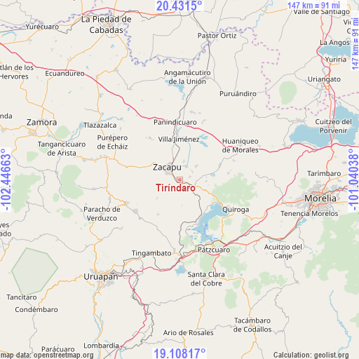
Tiríndaro GPS coordinates[2]
19° 46' 16.356" North, 101° 44' 36.6" West
| Map corner | latitude | longitude |
|---|---|---|
| Upper-left | 20.4315°, | -102.44663° |
| Center: | 19.77121°, | -101.7435° |
| Lower-right: | 19.10817°, | -101.04038° |
| Map W x H: | 147.1×147.1 km | = 91.4×91.4mi |
| max Lat: | 32.7° ⇑48% North |
| Tiríndaro: | 19.77121° |
| min Lat: | ⇓52% South 14.53588° |
| min Long | Tiríndaro | max Long |
| -117.105° | -101.7435° | -86.73105° |
| W 20.6%⇐ | ⇒79.4% E |
Elevation
Elevation of Tiríndaro is 1995 m = 6545 ft, and this is 741.3 m = 2432 ft above average elevation for this country.
| Max E: |
3497 m = 11473 ft | 26.8% |
| Tiríndaro | 1995 m 6545 ft | |
| Avg. | 1253.7 m = 4113 ft | |
Min E: |
-1 m = -3 ft | 73.2% |
See also: Mexico elevation on elevation.city.
Geographical zone
Tiríndaro is located in North Torrid zone (between Equator and Tropic of Cancer). Distance of this Northern Tropic circle is 407.6 km =253.3 mi to North.| Distance of | km | miles | from Tiríndaro |
|---|---|---|---|
| North Pole | 7808.7 | 4852.1 | to North |
| Arctic Circle | 5202.8 | 3232.9 | to North |
| Tropic Cancer | 407.6 | 253.3 | to North |
| Equator | 2198.4 | 1366 | to South |


Nearby cities:
15 places around Tiríndaro: (largest is in red/bold)
• Bellas Fuentes
8.7 km =5.4 mi,  50°
50°
• Cantabria
7.8 km =4.8 mi,  13°
13°
• Capula
9.9 km =6.2 mi,  216°
216°
• Comanjá
6.1 km =3.8 mi,  116°
116°
• Cortijo Nuevo
4.6 km =2.9 mi,  73°
73°
• Cortijo Viejo
6.1 km =3.8 mi,  59°
59°
• David Franco Reyes
2.5 km =1.6 mi,  130°
130°
• La Mojonera
12 km =7.5 mi,  231°
231°
• Lázaro Cárdenas (Colonia de Lázaro Cárdenas)
10 km =6.2 mi,  181°
181°
• Morelos
2.6 km =1.6 mi,  299°
299°
• Naranja de Tapia
1.8 km =1.1 mi,  291°
291°
• Santiago Azajo
9.3 km =5.8 mi,  140°
140°
• Tarejero
6.1 km =3.8 mi,  28°
28°
• Zacapu
7.4 km =4.6 mi,  319°
319°
• Zacapú
6.9 km =4.3 mi,  313°
313°
Sources, notices
• [Note1] Compared only with cities in Mexico existing in our database
• [Src1] Map data: © OpenStreetMap contributors (CC-BY-SA)
• [Src2] Other city data from geonames.org with taken over terms of usage.
• [Src3] Geographical zone / Annual Mean Temperature by Robert A. Rohde @ Wikipedia
