Comanjá geodata
Comanjá (Michoacán) is a populated place; located in Mexico in America/Mexico_City (GMT-6) time zone. With population of 1,495 people, there are 5773 cities with bigger population in this country. Compared to other cities in Mexico, 51.5% of cities are located further ↓South; 78.9% of cities are located further →East and 77.7% of cities have lower elevation than Comanjá. Note1


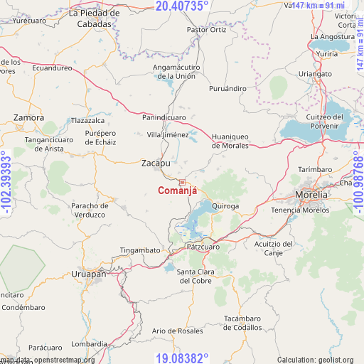
Comanjá GPS coordinates[2]
19° 44' 49.056" North, 101° 41' 26.88" West
| Map corner | latitude | longitude |
|---|---|---|
| Upper-left | 20.40735°, | -102.39393° |
| Center: | 19.74696°, | -101.6908° |
| Lower-right: | 19.08382°, | -100.98768° |
| Map W x H: | 147.2×147.2 km | = 91.5×91.5mi |
| max Lat: | 32.7° ⇑48.5% North |
| Comanjá: | 19.74696° |
| min Lat: | ⇓51.5% South 14.53588° |
| min Long | Comanjá | max Long |
| -117.105° | -101.6908° | -86.73105° |
| W 21.1%⇐ | ⇒78.9% E |
Elevation
Elevation of Comanjá is 2083 m = 6834 ft, and this is 829.3 m = 2721 ft above average elevation for this country.
| Max E: |
3497 m = 11473 ft | 22.3% |
| Comanjá | 2083 m 6834 ft | |
| Avg. | 1253.7 m = 4113 ft | |
Min E: |
-1 m = -3 ft | 77.7% |
See also: Mexico elevation on elevation.city.
Geographical zone
Comanjá is located in North Torrid zone (between Equator and Tropic of Cancer). Distance of this Northern Tropic circle is 410.3 km =254.9 mi to North.| Distance of | km | miles | from Comanjá |
|---|---|---|---|
| North Pole | 7811.4 | 4853.8 | to North |
| Arctic Circle | 5205.5 | 3234.5 | to North |
| Tropic Cancer | 410.3 | 254.9 | to North |
| Equator | 2195.7 | 1364.3 | to South |


Nearby cities:
15 places around Comanjá: (largest is in red/bold)
• Bellas Fuentes
8.4 km =5.2 mi,  8°
8°
• Cantabria
11 km =6.8 mi,  340°
340°
• Cortijo Nuevo
4.1 km =2.5 mi, 344°
• Cortijo Viejo
5.8 km =3.6 mi,  357°
357°
• David Franco Reyes
3.7 km =2.3 mi,  286°
286°
• Lázaro Cárdenas (Colonia de Lázaro Cárdenas)
9.3 km =5.8 mi,  218°
218°
• Matugeo
8 km =5 mi,  100°
100°
• Morelos
8.8 km =5.5 mi,  296°
296°
• Naranja de Tapia
7.9 km =4.9 mi, 294°
• San Andrés Ziróndaro
10.6 km =6.6 mi,  144°
144°
• San Jerónimo Purenchecuaro
11.1 km =6.9 mi,  132°
132°
• Santiago Azajo
4.5 km =2.8 mi,  174°
174°
• Tarejero
8.5 km =5.3 mi, 342°
• Tiríndaro
6.1 km =3.8 mi, 296°
• Tungüitiro
9.4 km =5.8 mi,  62°
62°
Sources, notices
• [Note1] Compared only with cities in Mexico existing in our database
• [Src1] Map data: © OpenStreetMap contributors (CC-BY-SA)
• [Src2] Other city data from geonames.org with taken over terms of usage.
• [Src3] Geographical zone / Annual Mean Temperature by Robert A. Rohde @ Wikipedia
